Malva geodata
Malva (Castille and León) is a seat of a third-order administrative division; located in Spain in Europe/Madrid (GMT+2) time zone. With population of 207 people, there are 4996 cities with bigger population in this country. Compared to other cities in Spain, 64.9% of cities are located further ↓South; 78.5% of cities are located further →East and 56% of cities have lower elevation than Malva. Note1


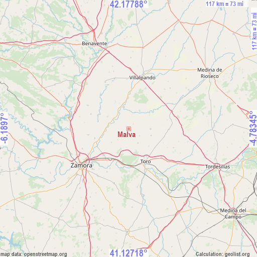
Malva GPS coordinates[2]
41° 39' 16.812" North, 5° 29' 11.652" West
| Map corner | latitude | longitude |
|---|---|---|
| Upper-left | 42.17788°, | -6.1897° |
| Center: | 41.65467°, | -5.48657° |
| Lower-right: | 41.12718°, | -4.78345° |
| Map W x H: | 116.8×116.8 km | = 72.6×72.6mi |
| max Lat: | 43.74134° ⇑35.1% North |
| Malva: | 41.65467° |
| min Lat: | ⇓64.9% South 27.64134° |
| min Long | Malva | max Long |
| -18.00367° | -5.48657° | 4.2899° |
| W 21.5%⇐ | ⇒78.5% E |
Elevation
Elevation of Malva is 716 m = 2349 ft, and this is 118 m = 387 ft above average elevation for this country.
| Max E: |
1682 m = 5518 ft | 44% |
| Malva | 716 m 2349 ft | |
| Avg. | 598 m = 1962 ft | |
Min E: |
0 m = 0 ft | 56% |
See also: Spain elevation on elevation.city.
Geographical zone
Malva is located in North temperate zone (between Tropic of Cancer and the Arctic Circle). Distance of this Northern Tropic circle is 2025.6 km =1258.6 mi to South.| Distance of | km | miles | from Malva |
|---|---|---|---|
| North Pole | 5375.5 | 3340.2 | to North |
| Arctic Circle | 2769.6 | 1720.9 | to North |
| Tropic Cancer | 2025.6 | 1258.6 | to South |
| Equator | 4631.6 | 2877.9 | to South |


Nearby cities:
15 places around Malva: (largest is in red/bold)
• Abezames
5.9 km =3.7 mi,  121°
121°
• Aspariegos
9.6 km =6 mi,  283°
283°
• Belver de los Montes
8.1 km =5 mi,  20°
20°
• Benegiles
12.7 km =7.9 mi,  255°
255°
• Bustillo del Oro
3 km =1.9 mi,  43°
43°
• Castronuevo
8.7 km =5.4 mi,  327°
327°
• Fuentesecas
2.9 km =1.8 mi,  156°
156°
• Gallegos del Pan
9.9 km =6.2 mi,  232°
232°
• Matilla la Seca
8.5 km =5.3 mi,  187°
187°
• Pinilla de Toro
10.6 km =6.6 mi,  106°
106°
• Pobladura de Valderaduey
6.8 km =4.2 mi,  317°
317°
• Pozoantiguo
7.6 km =4.7 mi,  146°
146°
• Vezdemarbán
10 km =6.2 mi,  89°
89°
• Villalube
7 km =4.3 mi,  224°
224°
• Villardondiego
12 km =7.5 mi,  130°
130°
Sources, notices
• [Note1] Compared only with cities in Spain existing in our database
• [Src1] Map data: © OpenStreetMap contributors (CC-BY-SA)
• [Src2] Other city data from geonames.org with taken over terms of usage.
• [Src3] Geographical zone / Annual Mean Temperature by Robert A. Rohde @ Wikipedia
