Carucedo geodata
Carucedo (Castille and León) is a seat of a third-order administrative division; located in Spain in Europe/Madrid (GMT+2) time zone. With population of 639 people, there are 3524 cities with bigger population in this country. Compared to other cities in Spain, 86.9% of cities are located further ↓South; 93.3% of cities are located further →East and 61.3% of cities have higher elevation than Carucedo. Note1


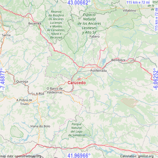
Carucedo GPS coordinates[2]
42° 29' 25.044" North, 6° 45' 56.34" West
| Map corner | latitude | longitude |
|---|---|---|
| Upper-left | 43.00662°, | -7.46877° |
| Center: | 42.49029°, | -6.76565° |
| Lower-right: | 41.96966°, | -6.06252° |
| Map W x H: | 115.3×115.3 km | = 71.6×71.6mi |
| max Lat: | 43.74134° ⇑13.1% North |
| Carucedo: | 42.49029° |
| min Lat: | ⇓86.9% South 27.64134° |
| min Long | Carucedo | max Long |
| -18.00367° | -6.76565° | 4.2899° |
| W 6.7%⇐ | ⇒93.3% E |
Elevation
Elevation of Carucedo is 508 m = 1667 ft, and this is 90 m = 295 ft below average elevation for this country.
| Max E: |
1682 m = 5518 ft | 61.3% |
| Avg. | 598 m = 1962 ft | |
| Carucedo | 508 m = 1667 ft | |
Min E: |
0 m = 0 ft | 38.7% |
See also: Spain elevation on elevation.city.
Geographical zone
Carucedo is located in North temperate zone (between Tropic of Cancer and the Arctic Circle). Distance of this Northern Tropic circle is 2118.6 km =1316.4 mi to South.| Distance of | km | miles | from Carucedo |
|---|---|---|---|
| North Pole | 5282.6 | 3282.5 | to North |
| Arctic Circle | 2676.7 | 1663.2 | to North |
| Tropic Cancer | 2118.6 | 1316.4 | to South |
| Equator | 4724.5 | 2935.7 | to South |


Nearby cities:
15 places around Carucedo: (largest is in red/bold)
• Arganza
18 km =11.2 mi,  21°
21°
• Benuza
11.1 km =6.9 mi,  155°
155°
• Borrenes
3.5 km =2.2 mi,  90°
90°
• Cacabelos
12.7 km =7.9 mi, 15°
• Camponaraya
12.7 km =7.9 mi,  39°
39°
• Carracedelo
7.8 km =4.8 mi, 20°
• Corullón
10.8 km =6.7 mi,  335°
335°
• Oencia
17.8 km =11.1 mi,  290°
290°
• Ponferrada
15.2 km =9.4 mi,  65°
65°
• Priaranza del Bierzo
8.1 km =5 mi, 74°
• Puente de Domingo Flórez
9.8 km =6.1 mi,  207°
207°
• Sobrado
7.5 km =4.7 mi, 292°
• Trabadelo
20 km =12.4 mi,  332°
332°
• Villadecanes
10 km =6.2 mi,  2°
2°
• Villafranca del Bierzo
13.4 km =8.3 mi, 344°
Sources, notices
• [Note1] Compared only with cities in Spain existing in our database
• [Src1] Map data: © OpenStreetMap contributors (CC-BY-SA)
• [Src2] Other city data from geonames.org with taken over terms of usage.
• [Src3] Geographical zone / Annual Mean Temperature by Robert A. Rohde @ Wikipedia
