Camponaraya geodata
Camponaraya (Castille and León) is a seat of a third-order administrative division; located in Spain in Europe/Madrid (GMT+2) time zone. With population of 3,500 people, there are 1587 cities with bigger population in this country. Compared to other cities in Spain, 88.9% of cities are located further ↓South; 92.5% of cities are located further →East and 62.5% of cities have higher elevation than Camponaraya. Note1
Administrative division(s):
- Level 1: Castille and León
- Level 2: Provincia de León
- Level 3: Camponaraya


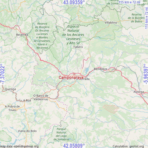
Camponaraya GPS coordinates[2]
42° 34' 40.764" North, 6° 40' 1.524" West
| Map corner | latitude | longitude |
|---|---|---|
| Upper-left | 43.09359°, | -7.37022° |
| Center: | 42.57799°, | -6.66709° |
| Lower-right: | 42.05809°, | -5.96397° |
| Map W x H: | 115.1×115.1 km | = 71.5×71.5mi |
| max Lat: | 43.74134° ⇑11.1% North |
| Camponaraya: | 42.57799° |
| min Lat: | ⇓88.9% South 27.64134° |
| min Long | Camponaraya | max Long |
| -18.00367° | -6.66709° | 4.2899° |
| W 7.5%⇐ | ⇒92.5% E |
Elevation
Elevation of Camponaraya is 492 m = 1614 ft, and this is 106 m = 348 ft below average elevation for this country.
| Max E: |
1682 m = 5518 ft | 62.5% |
| Avg. | 598 m = 1962 ft | |
| Camponaraya | 492 m = 1614 ft | |
Min E: |
0 m = 0 ft | 37.5% |
See also: Spain elevation on elevation.city.
Geographical zone
Camponaraya is located in North temperate zone (between Tropic of Cancer and the Arctic Circle). Distance of this Northern Tropic circle is 2128.3 km =1322.5 mi to South.| Distance of | km | miles | from Camponaraya |
|---|---|---|---|
| North Pole | 5272.8 | 3276.4 | to North |
| Arctic Circle | 2666.9 | 1657.1 | to North |
| Tropic Cancer | 2128.3 | 1322.5 | to South |
| Equator | 4734.2 | 2941.7 | to South |


Nearby cities:
15 places around Camponaraya: (largest is in red/bold)
• Arganza
7.2 km =4.5 mi,  347°
347°
• Borrenes
10.8 km =6.7 mi,  205°
205°
• Cacabelos
5.3 km =3.3 mi,  298°
298°
• Carracedelo
5.9 km =3.7 mi,  245°
245°
• Carucedo
12.7 km =7.9 mi,  219°
219°
• Castropodame
16.3 km =10.1 mi,  89°
89°
• Congosto
12.8 km =8 mi,  69°
69°
• Corullón
12.5 km =7.8 mi,  270°
270°
• Cubillos del Sil
10 km =6.2 mi,  58°
58°
• Molinaseca
12.8 km =8 mi,  110°
110°
• Ponferrada
6.8 km =4.2 mi,  120°
120°
• Priaranza del Bierzo
7.6 km =4.7 mi,  181°
181°
• Sancedo
10.2 km =6.3 mi,  15°
15°
• Villadecanes
7.6 km =4.7 mi, 271°
• Villafranca del Bierzo
12.2 km =7.6 mi,  284°
284°
Sources, notices
• [Note1] Compared only with cities in Spain existing in our database
• [Src1] Map data: © OpenStreetMap contributors (CC-BY-SA)
• [Src2] Other city data from geonames.org with taken over terms of usage.
• [Src3] Geographical zone / Annual Mean Temperature by Robert A. Rohde @ Wikipedia
