Arganza geodata
Arganza (Castille and León) is a seat of a third-order administrative division; located in Spain in Europe/Madrid (GMT+2) time zone. With population of 861 people, there are 3118 cities with bigger population in this country. Compared to other cities in Spain, 90.5% of cities are located further ↓South; 92.7% of cities are located further →East and 54.9% of cities have higher elevation than Arganza. Note1


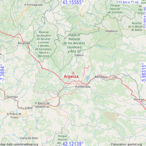
Arganza GPS coordinates[2]
42° 38' 26.772" North, 6° 41' 10.572" West
| Map corner | latitude | longitude |
|---|---|---|
| Upper-left | 43.15585°, | -7.3894° |
| Center: | 42.64077°, | -6.68627° |
| Lower-right: | 42.12139°, | -5.98315° |
| Map W x H: | 115×115 km | = 71.5×71.5mi |
| max Lat: | 43.74134° ⇑9.5% North |
| Arganza: | 42.64077° |
| min Lat: | ⇓90.5% South 27.64134° |
| min Long | Arganza | max Long |
| -18.00367° | -6.68627° | 4.2899° |
| W 7.3%⇐ | ⇒92.7% E |
Elevation
Elevation of Arganza is 596 m = 1955 ft, and this is 2 m = 7 ft below average elevation for this country.
| Max E: |
1682 m = 5518 ft | 54.9% |
| Avg. | 598 m = 1962 ft | |
| Arganza | 596 m = 1955 ft | |
Min E: |
0 m = 0 ft | 45.1% |
See also: Spain elevation on elevation.city.
Geographical zone
Arganza is located in North temperate zone (between Tropic of Cancer and the Arctic Circle). Distance of this Northern Tropic circle is 2135.3 km =1326.8 mi to South.| Distance of | km | miles | from Arganza |
|---|---|---|---|
| North Pole | 5265.9 | 3272.1 | to North |
| Arctic Circle | 2660 | 1652.8 | to North |
| Tropic Cancer | 2135.3 | 1326.8 | to South |
| Equator | 4741.2 | 2946 | to South |


Nearby cities:
15 places around Arganza: (largest is in red/bold)
• Berlanga del Bierzo
12 km =7.5 mi,  33°
33°
• Cacabelos
5.5 km =3.4 mi,  214°
214°
• Camponaraya
7.2 km =4.5 mi,  167°
167°
• Carracedelo
10.2 km =6.3 mi,  202°
202°
• Congosto
13.8 km =8.6 mi,  100°
100°
• Corullón
12.9 km =8 mi,  237°
237°
• Cubillos del Sil
10.2 km =6.3 mi, 99°
• Fabero
15 km =9.3 mi,  19°
19°
• Ponferrada
12.8 km =8 mi,  144°
144°
• Priaranza del Bierzo
14.6 km =9.1 mi, 174°
• Sancedo
5.1 km =3.2 mi,  55°
55°
• Toreno
15.6 km =9.7 mi,  65°
65°
• Vega de Espinareda
9.8 km =6.1 mi, 15°
• Villadecanes
9.1 km =5.7 mi,  221°
221°
• Villafranca del Bierzo
10.9 km =6.8 mi,  249°
249°
Sources, notices
• [Note1] Compared only with cities in Spain existing in our database
• [Src1] Map data: © OpenStreetMap contributors (CC-BY-SA)
• [Src2] Other city data from geonames.org with taken over terms of usage.
• [Src3] Geographical zone / Annual Mean Temperature by Robert A. Rohde @ Wikipedia
