Calvos geodata
Calvos (Galicia) is a populated place; located in Spain in Europe/Madrid (GMT+2) time zone. With population of 1,187 people, there are 2732 cities with bigger population in this country. Compared to other cities in Spain, 72.2% of cities are located further ↓South; 96.1% of cities are located further →East and 80.4% of cities have lower elevation than Calvos. Note1
Administrative division(s):
- Level 1: Galicia
- Level 2: Provincia de Ourense
- Level 3: Calvos de Randín


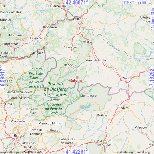
Calvos GPS coordinates[2]
41° 56' 52.44" North, 7° 53' 45.744" West
| Map corner | latitude | longitude |
|---|---|---|
| Upper-left | 42.46871°, | -8.59917° |
| Center: | 41.9479°, | -7.89604° |
| Lower-right: | 41.42281°, | -7.19292° |
| Map W x H: | 116.3×116.3 km | = 72.3×72.3mi |
| max Lat: | 43.74134° ⇑27.8% North |
| Calvos: | 41.9479° |
| min Lat: | ⇓72.2% South 27.64134° |
| min Long | Calvos | max Long |
| -18.00367° | -7.89604° | 4.2899° |
| W 3.9%⇐ | ⇒96.1% E |
Elevation
Elevation of Calvos is 901 m = 2956 ft, and this is 303 m = 994 ft above average elevation for this country.
| Max E: |
1682 m = 5518 ft | 19.6% |
| Calvos | 901 m 2956 ft | |
| Avg. | 598 m = 1962 ft | |
Min E: |
0 m = 0 ft | 80.4% |
See also: Spain elevation on elevation.city.
Geographical zone
Calvos is located in North temperate zone (between Tropic of Cancer and the Arctic Circle). Distance of this Northern Tropic circle is 2058.3 km =1279 mi to South.| Distance of | km | miles | from Calvos |
|---|---|---|---|
| North Pole | 5342.9 | 3319.9 | to North |
| Arctic Circle | 2737 | 1700.7 | to North |
| Tropic Cancer | 2058.3 | 1279 | to South |
| Equator | 4664.2 | 2898.2 | to South |


Nearby cities:
15 places around Calvos: (largest is in red/bold)
• Allariz
28.1 km =17.5 mi,  16°
16°
• Baltar
14.9 km =9.3 mi,  88°
88°
• Bande
11.3 km =7 mi,  324°
324°
• Blancos
13.1 km =8.1 mi,  65°
65°
• Celanova
23.3 km =14.5 mi,  347°
347°
• Cualedro
25.3 km =15.7 mi,  79°
79°
• Entrimo
18.4 km =11.4 mi,  264°
264°
• Lobios
17.8 km =11.1 mi,  242°
242°
• Muiños
6.5 km =4 mi,  278°
278°
• Porqueira
8.5 km =5.3 mi,  26°
26°
• Quintela de Leirado
27.2 km =16.9 mi, 321°
• Rairiz de Veiga
15.9 km =9.9 mi, 18°
• Trasmiras
24.6 km =15.3 mi, 69°
• Verea
19.7 km =12.2 mi,  333°
333°
• Xinzo de Limia
19.1 km =11.9 mi,  47°
47°
Sources, notices
• [Note1] Compared only with cities in Spain existing in our database
• [Src1] Map data: © OpenStreetMap contributors (CC-BY-SA)
• [Src2] Other city data from geonames.org with taken over terms of usage.
• [Src3] Geographical zone / Annual Mean Temperature by Robert A. Rohde @ Wikipedia
