Baltar geodata
Baltar (Galicia) is a seat of a third-order administrative division; located in Spain in Europe/Madrid (GMT+2) time zone. With population of 1,166 people, there are 2758 cities with bigger population in this country. Compared to other cities in Spain, 72.4% of cities are located further ↓South; 95.8% of cities are located further →East and 71.2% of cities have lower elevation than Baltar. Note1


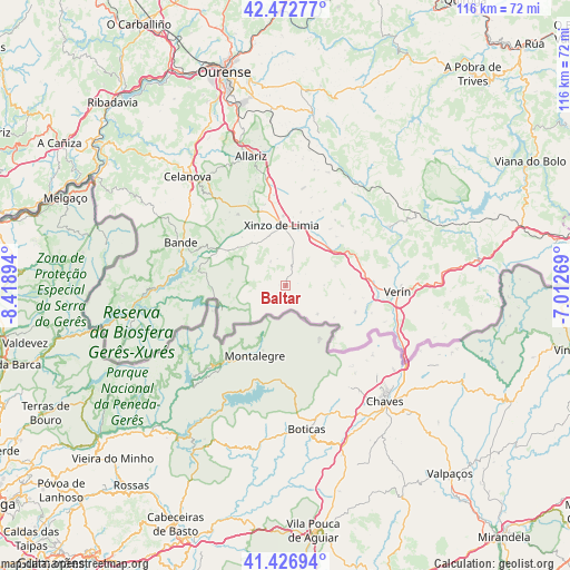
Baltar GPS coordinates[2]
41° 57' 7.2" North, 7° 42' 56.916" West
| Map corner | latitude | longitude |
|---|---|---|
| Upper-left | 42.47277°, | -8.41894° |
| Center: | 41.952°, | -7.71581° |
| Lower-right: | 41.42694°, | -7.01269° |
| Map W x H: | 116.3×116.3 km | = 72.3×72.3mi |
| max Lat: | 43.74134° ⇑27.6% North |
| Baltar: | 41.952° |
| min Lat: | ⇓72.4% South 27.64134° |
| min Long | Baltar | max Long |
| -18.00367° | -7.71581° | 4.2899° |
| W 4.2%⇐ | ⇒95.8% E |
Elevation
Elevation of Baltar is 822 m = 2697 ft, and this is 224 m = 735 ft above average elevation for this country.
| Max E: |
1682 m = 5518 ft | 28.8% |
| Baltar | 822 m 2697 ft | |
| Avg. | 598 m = 1962 ft | |
Min E: |
0 m = 0 ft | 71.2% |
See also: Spain elevation on elevation.city.
Geographical zone
Baltar is located in North temperate zone (between Tropic of Cancer and the Arctic Circle). Distance of this Northern Tropic circle is 2058.7 km =1279.2 mi to South.| Distance of | km | miles | from Baltar |
|---|---|---|---|
| North Pole | 5342.4 | 3319.6 | to North |
| Arctic Circle | 2736.5 | 1700.4 | to North |
| Tropic Cancer | 2058.7 | 1279.2 | to South |
| Equator | 4664.6 | 2898.4 | to South |


Nearby cities:
15 places around Baltar: (largest is in red/bold)
• Allariz
27.4 km =17 mi,  345°
345°
• Ambía
28.3 km =17.6 mi,  356°
356°
• Bande
23.2 km =14.4 mi,  292°
292°
• Blancos
5.8 km =3.6 mi,  329°
329°
• Calvos
14.9 km =9.3 mi,  268°
268°
• Cualedro
10.8 km =6.7 mi,  67°
67°
• Laza
24.2 km =15 mi,  59°
59°
• Muiños
21.4 km =13.3 mi, 271°
• Oimbra
21.5 km =13.4 mi,  110°
110°
• Porqueira
13.2 km =8.2 mi,  302°
302°
• Rairiz de Veiga
17.6 km =10.9 mi, 326°
• Sarreaus
17.7 km =11 mi,  31°
31°
• Trasmiras
11.5 km =7.1 mi,  44°
44°
• Verín
23 km =14.3 mi,  92°
92°
• Xinzo de Limia
12.4 km =7.7 mi, 356°
Sources, notices
• [Note1] Compared only with cities in Spain existing in our database
• [Src1] Map data: © OpenStreetMap contributors (CC-BY-SA)
• [Src2] Other city data from geonames.org with taken over terms of usage.
• [Src3] Geographical zone / Annual Mean Temperature by Robert A. Rohde @ Wikipedia
