Allariz geodata
Allariz (Galicia) is a seat of a third-order administrative division; located in Spain in Europe/Madrid (GMT+2) time zone. With population of 5,392 people, there are 1233 cities with bigger population in this country. Compared to other cities in Spain, 79% of cities are located further ↓South; 95.9% of cities are located further →East and 64.4% of cities have higher elevation than Allariz. Note1


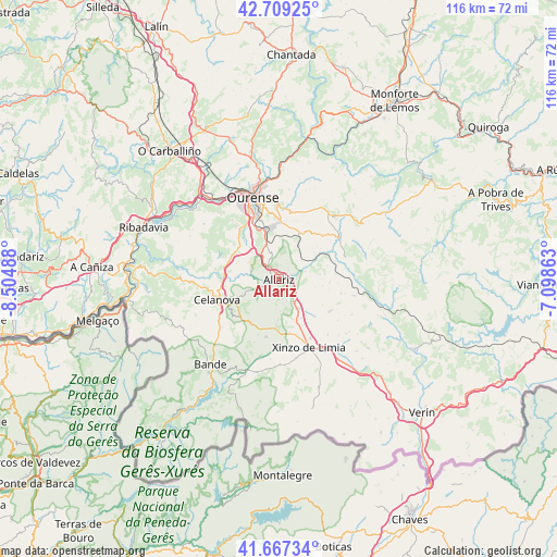
Allariz GPS coordinates[2]
42° 11' 25.584" North, 7° 48' 6.3" West
| Map corner | latitude | longitude |
|---|---|---|
| Upper-left | 42.70925°, | -8.50488° |
| Center: | 42.19044°, | -7.80175° |
| Lower-right: | 41.66734°, | -7.09863° |
| Map W x H: | 115.8×115.8 km | = 72×72mi |
| max Lat: | 43.74134° ⇑21% North |
| Allariz: | 42.19044° |
| min Lat: | ⇓79% South 27.64134° |
| min Long | Allariz | max Long |
| -18.00367° | -7.80175° | 4.2899° |
| W 4.1%⇐ | ⇒95.9% E |
Elevation
Elevation of Allariz is 467 m = 1532 ft, and this is 131 m = 430 ft below average elevation for this country.
| Max E: |
1682 m = 5518 ft | 64.4% |
| Avg. | 598 m = 1962 ft | |
| Allariz | 467 m = 1532 ft | |
Min E: |
0 m = 0 ft | 35.6% |
See also: Spain elevation on elevation.city.
Geographical zone
Allariz is located in North temperate zone (between Tropic of Cancer and the Arctic Circle). Distance of this Northern Tropic circle is 2085.2 km =1295.7 mi to South.| Distance of | km | miles | from Allariz |
|---|---|---|---|
| North Pole | 5315.9 | 3303.1 | to North |
| Arctic Circle | 2710 | 1683.9 | to North |
| Tropic Cancer | 2085.2 | 1295.7 | to South |
| Equator | 4691.1 | 2914.9 | to South |


Nearby cities:
15 places around Allariz: (largest is in red/bold)
• Ambía
5.6 km =3.5 mi,  72°
72°
• Baños de Molgas
12.1 km =7.5 mi,  61°
61°
• Blancos
22 km =13.7 mi,  169°
169°
• Celanova
13.3 km =8.3 mi,  251°
251°
• Esgos
17.3 km =10.7 mi,  29°
29°
• Maceda
15.3 km =9.5 mi,  54°
54°
• Ourense
17.1 km =10.6 mi,  342°
342°
• Pereiro de Aguiar
17.2 km =10.7 mi,  0°
0°
• Porqueira
19.7 km =12.2 mi,  191°
191°
• Rairiz de Veiga
12.2 km =7.6 mi, 193°
• Sarreaus
19.9 km =12.4 mi,  124°
124°
• Taboadela
6.1 km =3.8 mi, 340°
• Toén
18.9 km =11.7 mi,  318°
318°
• Verea
18.9 km =11.7 mi,  240°
240°
• Xinzo de Limia
15.5 km =9.6 mi,  155°
155°
Sources, notices
• [Note1] Compared only with cities in Spain existing in our database
• [Src1] Map data: © OpenStreetMap contributors (CC-BY-SA)
• [Src2] Other city data from geonames.org with taken over terms of usage.
• [Src3] Geographical zone / Annual Mean Temperature by Robert A. Rohde @ Wikipedia
