Boada geodata
Boada (Castille and León) is a seat of a third-order administrative division; located in Spain in Europe/Madrid (GMT+2) time zone. With population of 359 people, there are 4279 cities with bigger population in this country. Compared to other cities in Spain, 55.8% of cities are located further ↑North; 89.5% of cities are located further →East and 65.4% of cities have lower elevation than Boada. Note1
Administrative division(s):
- Level 1: Castille and León
- Level 2: Provincia de Salamanca
- Level 3: Boada


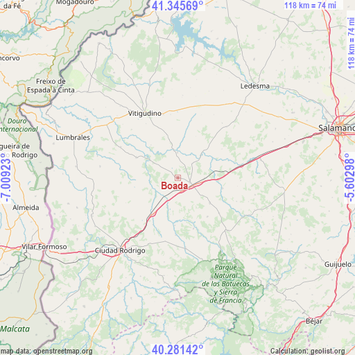
Boada GPS coordinates[2]
40° 48' 56.484" North, 6° 18' 21.996" West
| Map corner | latitude | longitude |
|---|---|---|
| Upper-left | 41.34569°, | -7.00923° |
| Center: | 40.81569°, | -6.30611° |
| Lower-right: | 40.28142°, | -5.60298° |
| Map W x H: | 118.3×118.3 km | = 73.5×73.5mi |
| max Lat: | 43.74134° ⇑55.8% North |
| Boada: | 40.81569° |
| min Lat: | ⇓44.2% South 27.64134° |
| min Long | Boada | max Long |
| -18.00367° | -6.30611° | 4.2899° |
| W 10.5%⇐ | ⇒89.5% E |
Elevation
Elevation of Boada is 780 m = 2559 ft, and this is 182 m = 597 ft above average elevation for this country.
| Max E: |
1682 m = 5518 ft | 34.6% |
| Boada | 780 m 2559 ft | |
| Avg. | 598 m = 1962 ft | |
Min E: |
0 m = 0 ft | 65.4% |
See also: Spain elevation on elevation.city.
Geographical zone
Boada is located in North temperate zone (between Tropic of Cancer and the Arctic Circle). Distance of this Northern Tropic circle is 1932.4 km =1200.7 mi to South.| Distance of | km | miles | from Boada |
|---|---|---|---|
| North Pole | 5468.8 | 3398.2 | to North |
| Arctic Circle | 2862.9 | 1778.9 | to North |
| Tropic Cancer | 1932.4 | 1200.7 | to South |
| Equator | 4538.3 | 2820 | to South |


Nearby cities:
15 places around Boada: (largest is in red/bold)
• Alba de Yeltes
16 km =9.9 mi,  183°
183°
• Buenamadre
6.6 km =4.1 mi,  45°
45°
• Cabrillas
13.6 km =8.5 mi,  128°
128°
• Castraz
12.5 km =7.8 mi,  190°
190°
• Cipérez
16.6 km =10.3 mi,  11°
11°
• El Cubo de Don Sancho
8.4 km =5.2 mi,  0°
0°
• La Fuente de San Esteban
4.3 km =2.7 mi,  111°
111°
• Martín de Yeltes
4.6 km =2.9 mi,  164°
164°
• Pelarrodríguez
11.2 km =7 mi,  44°
44°
• Pozos de Hinojo
14 km =8.7 mi,  320°
320°
• Retortillo
4.8 km =3 mi,  250°
250°
• San Muñoz
15.5 km =9.6 mi,  103°
103°
• Sancti Spíritus
14.6 km =9.1 mi,  212°
212°
• Villares de Yeltes
10.6 km =6.6 mi,  301°
301°
• Villavieja de Yeltes
15.2 km =9.4 mi, 296°
Sources, notices
• [Note1] Compared only with cities in Spain existing in our database
• [Src1] Map data: © OpenStreetMap contributors (CC-BY-SA)
• [Src2] Other city data from geonames.org with taken over terms of usage.
• [Src3] Geographical zone / Annual Mean Temperature by Robert A. Rohde @ Wikipedia
