Buenamadre geodata
Buenamadre (Castille and León) is a seat of a third-order administrative division; located in Spain in Europe/Madrid (GMT+2) time zone. With population of 152 people, there are 5413 cities with bigger population in this country. Compared to other cities in Spain, 54.8% of cities are located further ↑North; 89% of cities are located further →East and 62.1% of cities have lower elevation than Buenamadre. Note1
Administrative division(s):
- Level 1: Castille and León
- Level 2: Provincia de Salamanca
- Level 3: Buenamadre


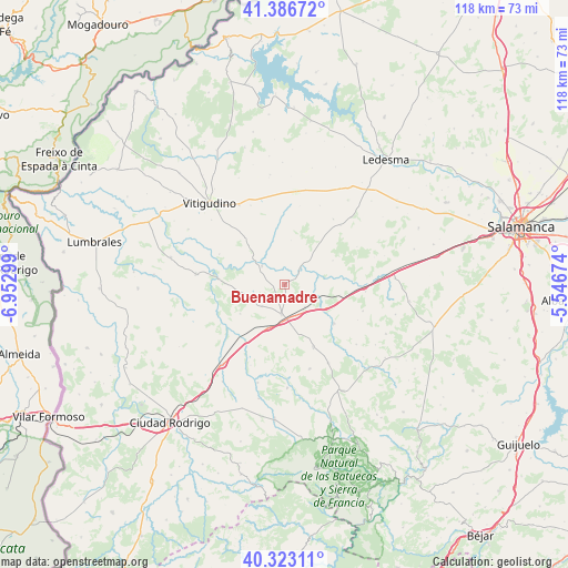
Buenamadre GPS coordinates[2]
40° 51' 25.38" North, 6° 14' 59.532" West
| Map corner | latitude | longitude |
|---|---|---|
| Upper-left | 41.38672°, | -6.95299° |
| Center: | 40.85705°, | -6.24987° |
| Lower-right: | 40.32311°, | -5.54674° |
| Map W x H: | 118.3×118.3 km | = 73.5×73.5mi |
| max Lat: | 43.74134° ⇑54.8% North |
| Buenamadre: | 40.85705° |
| min Lat: | ⇓45.2% South 27.64134° |
| min Long | Buenamadre | max Long |
| -18.00367° | -6.24987° | 4.2899° |
| W 11%⇐ | ⇒89% E |
Elevation
Elevation of Buenamadre is 757 m = 2484 ft, and this is 159 m = 522 ft above average elevation for this country.
| Max E: |
1682 m = 5518 ft | 37.9% |
| Buenamadre | 757 m 2484 ft | |
| Avg. | 598 m = 1962 ft | |
Min E: |
0 m = 0 ft | 62.1% |
See also: Spain elevation on elevation.city.
Geographical zone
Buenamadre is located in North temperate zone (between Tropic of Cancer and the Arctic Circle). Distance of this Northern Tropic circle is 1937 km =1203.6 mi to South.| Distance of | km | miles | from Buenamadre |
|---|---|---|---|
| North Pole | 5464.2 | 3395.3 | to North |
| Arctic Circle | 2858.3 | 1776.1 | to North |
| Tropic Cancer | 1937 | 1203.6 | to South |
| Equator | 4542.9 | 2822.8 | to South |


Nearby cities:
15 places around Buenamadre: (largest is in red/bold)
• Aldehuela de la Bóveda
16.6 km =10.3 mi,  92°
92°
• Boada
6.6 km =4.1 mi,  225°
225°
• Cabrillas
14.3 km =8.9 mi,  155°
155°
• Cipérez
11.8 km =7.3 mi,  353°
353°
• El Cubo de Don Sancho
6 km =3.7 mi,  308°
308°
• Garcirrey
11.1 km =6.9 mi,  64°
64°
• La Fuente de San Esteban
6.2 km =3.9 mi,  186°
186°
• Martín de Yeltes
9.7 km =6 mi,  201°
201°
• Pelarrodríguez
4.6 km =2.9 mi,  42°
42°
• Pozos de Hinojo
14.9 km =9.3 mi,  294°
294°
• Retortillo
11.1 km =6.9 mi,  236°
236°
• San Muñoz
13.2 km =8.2 mi,  128°
128°
• Sando
16.9 km =10.5 mi, 43°
• Santa María de Sando
16.9 km =10.5 mi, 36°
• Villares de Yeltes
13.8 km =8.6 mi,  274°
274°
Sources, notices
• [Note1] Compared only with cities in Spain existing in our database
• [Src1] Map data: © OpenStreetMap contributors (CC-BY-SA)
• [Src2] Other city data from geonames.org with taken over terms of usage.
• [Src3] Geographical zone / Annual Mean Temperature by Robert A. Rohde @ Wikipedia
