San Muñoz geodata
San Muñoz (Castille and León) is a seat of a third-order administrative division; located in Spain in Europe/Madrid (GMT+2) time zone. With population of 316 people, there are 4434 cities with bigger population in this country. Compared to other cities in Spain, 56.5% of cities are located further ↑North; 87.7% of cities are located further →East and 65.7% of cities have lower elevation than San Muñoz. Note1
Administrative division(s):
- Level 1: Castille and León
- Level 2: Provincia de Salamanca
- Level 3: San Muñoz


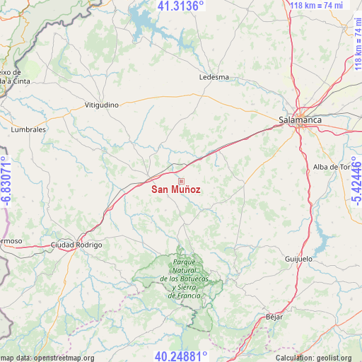
San Muñoz GPS coordinates[2]
40° 47' 0.024" North, 6° 7' 39.288" West
| Map corner | latitude | longitude |
|---|---|---|
| Upper-left | 41.3136°, | -6.83071° |
| Center: | 40.78334°, | -6.12758° |
| Lower-right: | 40.24881°, | -5.42446° |
| Map W x H: | 118.4×118.4 km | = 73.6×73.6mi |
| max Lat: | 43.74134° ⇑56.5% North |
| San Muñoz: | 40.78334° |
| min Lat: | ⇓43.5% South 27.64134° |
| min Long | San Muñoz | max Long |
| -18.00367° | -6.12758° | 4.2899° |
| W 12.3%⇐ | ⇒87.7% E |
Elevation
Elevation of San Muñoz is 782 m = 2566 ft, and this is 184 m = 604 ft above average elevation for this country.
| Max E: |
1682 m = 5518 ft | 34.3% |
| San Muñoz | 782 m 2566 ft | |
| Avg. | 598 m = 1962 ft | |
Min E: |
0 m = 0 ft | 65.7% |
See also: Spain elevation on elevation.city.
Geographical zone
San Muñoz is located in North temperate zone (between Tropic of Cancer and the Arctic Circle). Distance of this Northern Tropic circle is 1928.8 km =1198.5 mi to South.| Distance of | km | miles | from San Muñoz |
|---|---|---|---|
| North Pole | 5472.4 | 3400.4 | to North |
| Arctic Circle | 2866.5 | 1781.2 | to North |
| Tropic Cancer | 1928.8 | 1198.5 | to South |
| Equator | 4534.7 | 2817.7 | to South |


Nearby cities:
15 places around San Muñoz: (largest is in red/bold)
• Abusejo
8.3 km =5.2 mi,  187°
187°
• Aldehuela de la Bóveda
9.8 km =6.1 mi,  40°
40°
• Berrocal de Huebra
12.9 km =8 mi,  123°
123°
• Boada
15.5 km =9.6 mi,  283°
283°
• Buenamadre
13.2 km =8.2 mi,  308°
308°
• Cabrillas
6.5 km =4 mi,  221°
221°
• Carrascal del Obispo
11 km =6.8 mi,  101°
101°
• Garcirrey
13 km =8.1 mi,  358°
358°
• La Fuente de San Esteban
11.2 km =7 mi, 280°
• Martín de Yeltes
13.8 km =8.6 mi,  266°
266°
• Pelarrodríguez
13.6 km =8.5 mi,  328°
328°
• Robliza de Cojos
15.7 km =9.8 mi,  53°
53°
• Sanchón de la Sagrada
9.7 km =6 mi, 117°
• Tamames
14.1 km =8.8 mi,  172°
172°
• Villalba de los Llanos
12.9 km =8 mi,  81°
81°
Sources, notices
• [Note1] Compared only with cities in Spain existing in our database
• [Src1] Map data: © OpenStreetMap contributors (CC-BY-SA)
• [Src2] Other city data from geonames.org with taken over terms of usage.
• [Src3] Geographical zone / Annual Mean Temperature by Robert A. Rohde @ Wikipedia
