Mamblas geodata
Mamblas (Castille and León) is a seat of a third-order administrative division; located in Spain in Europe/Madrid (GMT+2) time zone. With population of 258 people, there are 4698 cities with bigger population in this country. Compared to other cities in Spain, 51.1% of cities are located further ↑North; 72.6% of cities are located further →East and 70.6% of cities have lower elevation than Mamblas. Note1


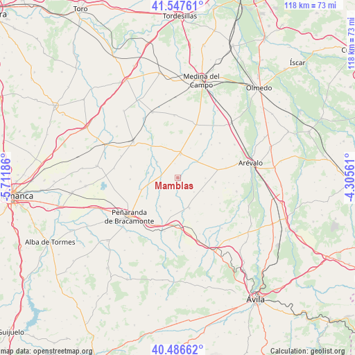
Mamblas GPS coordinates[2]
41° 1' 9.3" North, 5° 0' 31.428" West
| Map corner | latitude | longitude |
|---|---|---|
| Upper-left | 41.54761°, | -5.71186° |
| Center: | 41.01925°, | -5.00873° |
| Lower-right: | 40.48662°, | -4.30561° |
| Map W x H: | 118×118 km | = 73.3×73.3mi |
| max Lat: | 43.74134° ⇑51.1% North |
| Mamblas: | 41.01925° |
| min Lat: | ⇓48.9% South 27.64134° |
| min Long | Mamblas | max Long |
| -18.00367° | -5.00873° | 4.2899° |
| W 27.4%⇐ | ⇒72.6% E |
Elevation
Elevation of Mamblas is 818 m = 2684 ft, and this is 220 m = 722 ft above average elevation for this country.
| Max E: |
1682 m = 5518 ft | 29.4% |
| Mamblas | 818 m 2684 ft | |
| Avg. | 598 m = 1962 ft | |
Min E: |
0 m = 0 ft | 70.6% |
See also: Spain elevation on elevation.city.
Geographical zone
Mamblas is located in North temperate zone (between Tropic of Cancer and the Arctic Circle). Distance of this Northern Tropic circle is 1955 km =1214.8 mi to South.| Distance of | km | miles | from Mamblas |
|---|---|---|---|
| North Pole | 5446.1 | 3384 | to North |
| Arctic Circle | 2840.3 | 1764.9 | to North |
| Tropic Cancer | 1955 | 1214.8 | to South |
| Equator | 4560.9 | 2834 | to South |


Nearby cities:
15 places around Mamblas: (largest is in red/bold)
• Barromán
8.3 km =5.2 mi,  51°
51°
• Bercial de Zapardiel
4.5 km =2.8 mi, 47°
• Cabezas del Pozo
5 km =3.1 mi,  113°
113°
• Canales
9.2 km =5.7 mi,  101°
101°
• Cantiveros
8.7 km =5.4 mi,  148°
148°
• Castellanos de Zapardiel
11 km =6.8 mi, 48°
• Cisla
5.9 km =3.7 mi,  184°
184°
• Fontiveros
10.6 km =6.6 mi,  159°
159°
• Fuentes de Año
9.2 km =5.7 mi,  91°
91°
• Horcajo de las Torres
8.6 km =5.3 mi,  306°
306°
• Madrigal de las Altas Torres
7.9 km =4.9 mi,  6°
6°
• Moraleja de Matacabras
10.7 km =6.6 mi,  23°
23°
• Muñosancho
11.2 km =7 mi,  191°
191°
• Rasueros
5.5 km =3.4 mi,  274°
274°
• Rágama
10.2 km =6.3 mi,  256°
256°
Sources, notices
• [Note1] Compared only with cities in Spain existing in our database
• [Src1] Map data: © OpenStreetMap contributors (CC-BY-SA)
• [Src2] Other city data from geonames.org with taken over terms of usage.
• [Src3] Geographical zone / Annual Mean Temperature by Robert A. Rohde @ Wikipedia
