Arruazu geodata
Arruazu (Navarre) is a seat of a third-order administrative division; located in Spain in Europe/Madrid (GMT+2) time zone. With population of 103 people, there are 5896 cities with bigger population in this country. Compared to other cities in Spain, 93.8% of cities are located further ↓South; 67.5% of cities are located further ←West and 64.3% of cities have higher elevation than Arruazu. Note1


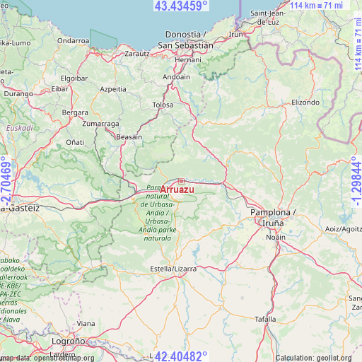
Arruazu GPS coordinates[2]
42° 55' 18.696" North, 2° 0' 5.652" West
| Map corner | latitude | longitude |
|---|---|---|
| Upper-left | 43.43459°, | -2.70469° |
| Center: | 42.92186°, | -2.00157° |
| Lower-right: | 42.40482°, | -1.29844° |
| Map W x H: | 114.5×114.5 km | = 71.1×71.1mi |
| max Lat: | 43.74134° ⇑6.2% North |
| Arruazu: | 42.92186° |
| min Lat: | ⇓93.8% South 27.64134° |
| min Long | Arruazu | max Long |
| -18.00367° | -2.00157° | 4.2899° |
| W 67.5%⇐ | ⇒32.5% E |
Elevation
Elevation of Arruazu is 469 m = 1539 ft, and this is 129 m = 423 ft below average elevation for this country.
| Max E: |
1682 m = 5518 ft | 64.3% |
| Avg. | 598 m = 1962 ft | |
| Arruazu | 469 m = 1539 ft | |
Min E: |
0 m = 0 ft | 35.7% |
See also: Spain elevation on elevation.city.
Geographical zone
Arruazu is located in North temperate zone (between Tropic of Cancer and the Arctic Circle). Distance of this Northern Tropic circle is 2166.5 km =1346.2 mi to South.| Distance of | km | miles | from Arruazu |
|---|---|---|---|
| North Pole | 5234.6 | 3252.6 | to North |
| Arctic Circle | 2628.7 | 1633.4 | to North |
| Tropic Cancer | 2166.5 | 1346.2 | to South |
| Equator | 4772.5 | 2965.5 | to South |


Nearby cities:
15 places around Arruazu: (largest is in red/bold)
• Abaltzisketa
16.3 km =10.1 mi,  328°
328°
• Altsasu
13.5 km =8.4 mi,  259°
259°
• Amezketa
15.6 km =9.7 mi, 334°
• Arbizu
3.1 km =1.9 mi, 256°
• Bakaiku
8.8 km =5.5 mi,  248°
248°
• Betelu
11.7 km =7.3 mi,  8°
8°
• Echarri-Aranaz
5.4 km =3.4 mi, 253°
• Goñi
11.2 km =7 mi,  134°
134°
• Irañeta
4.5 km =2.8 mi,  88°
88°
• Irurtzun
13.7 km =8.5 mi, 92°
• Iturmendi
10.2 km =6.3 mi, 249°
• Lakuntza
1.8 km =1.1 mi,  272°
272°
• Lekunberri
12.5 km =7.8 mi,  45°
45°
• Lezáun
16.1 km =10 mi,  177°
177°
• Urdiáin
11.6 km =7.2 mi, 251°
Sources, notices
• [Note1] Compared only with cities in Spain existing in our database
• [Src1] Map data: © OpenStreetMap contributors (CC-BY-SA)
• [Src2] Other city data from geonames.org with taken over terms of usage.
• [Src3] Geographical zone / Annual Mean Temperature by Robert A. Rohde @ Wikipedia
