Altsasu geodata
Altsasu (Navarre) is a populated place; located in Spain in Europe/Madrid (GMT+2) time zone. With population of 7,410 people, there are 988 cities with bigger population in this country. Compared to other cities in Spain, 93.6% of cities are located further ↓South; 65.2% of cities are located further ←West and 60.8% of cities have higher elevation than Altsasu. Note1


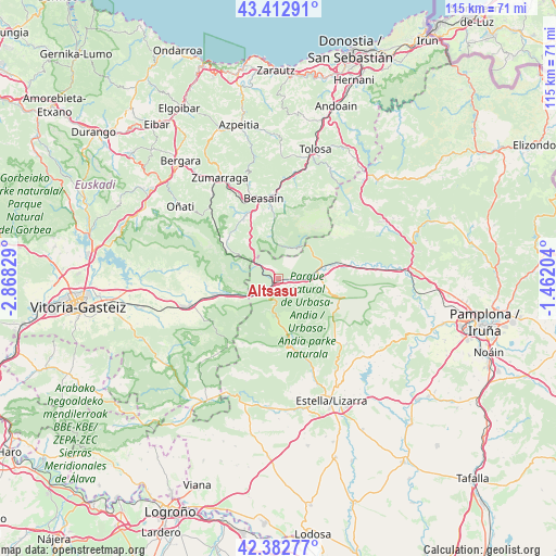
Altsasu GPS coordinates[2]
42° 53' 59.964" North, 2° 9' 54.576" West
| Map corner | latitude | longitude |
|---|---|---|
| Upper-left | 43.41291°, | -2.86829° |
| Center: | 42.89999°, | -2.16516° |
| Lower-right: | 42.38277°, | -1.46204° |
| Map W x H: | 114.5×114.5 km | = 71.1×71.1mi |
| max Lat: | 43.74134° ⇑6.4% North |
| Altsasu: | 42.89999° |
| min Lat: | ⇓93.6% South 27.64134° |
| min Long | Altsasu | max Long |
| -18.00367° | -2.16516° | 4.2899° |
| W 65.2%⇐ | ⇒34.8% E |
Elevation
Elevation of Altsasu is 517 m = 1696 ft, and this is 81 m = 266 ft below average elevation for this country.
| Max E: |
1682 m = 5518 ft | 60.8% |
| Avg. | 598 m = 1962 ft | |
| Altsasu | 517 m = 1696 ft | |
Min E: |
0 m = 0 ft | 39.2% |
See also: Spain elevation on elevation.city.
Geographical zone
Altsasu is located in North temperate zone (between Tropic of Cancer and the Arctic Circle). Distance of this Northern Tropic circle is 2164.1 km =1344.7 mi to South.| Distance of | km | miles | from Altsasu |
|---|---|---|---|
| North Pole | 5237 | 3254.1 | to North |
| Arctic Circle | 2631.1 | 1634.9 | to North |
| Tropic Cancer | 2164.1 | 1344.7 | to South |
| Equator | 4770 | 2963.9 | to South |


Nearby cities:
15 places around Altsasu: (largest is in red/bold)
• Araia
12.1 km =7.5 mi,  266°
266°
• Arbizu
10.4 km =6.5 mi,  80°
80°
• Arruazu
13.5 km =8.4 mi, 79°
• Ataun
11.8 km =7.3 mi,  355°
355°
• Bakaiku
5.2 km =3.2 mi,  99°
99°
• Echarri-Aranaz
8.2 km =5.1 mi, 83°
• Eulate
14.1 km =8.8 mi,  193°
193°
• Idiazabal
13.6 km =8.5 mi,  335°
335°
• Iturmendi
3.9 km =2.4 mi,  106°
106°
• Lakuntza
11.8 km =7.3 mi, 77°
• Olazagutía
3.6 km =2.2 mi,  222°
222°
• Segura
14 km =8.7 mi,  328°
328°
• Urdiáin
2.7 km =1.7 mi,  119°
119°
• Zegama
13.2 km =8.2 mi,  309°
309°
• Ziordia
6.2 km =3.9 mi,  238°
238°
Sources, notices
• [Note1] Compared only with cities in Spain existing in our database
• [Src1] Map data: © OpenStreetMap contributors (CC-BY-SA)
• [Src2] Other city data from geonames.org with taken over terms of usage.
• [Src3] Geographical zone / Annual Mean Temperature by Robert A. Rohde @ Wikipedia
