Zegama geodata
Zegama (Basque Country) is a seat of a third-order administrative division; located in Spain in Europe/Madrid (GMT+2) time zone. In our database, there are 6762 cities with bigger population. Compared to other cities in Spain, 94.2% of cities are located further ↓South; 63.6% of cities are located further ←West and 74.6% of cities have higher elevation than Zegama. Note1


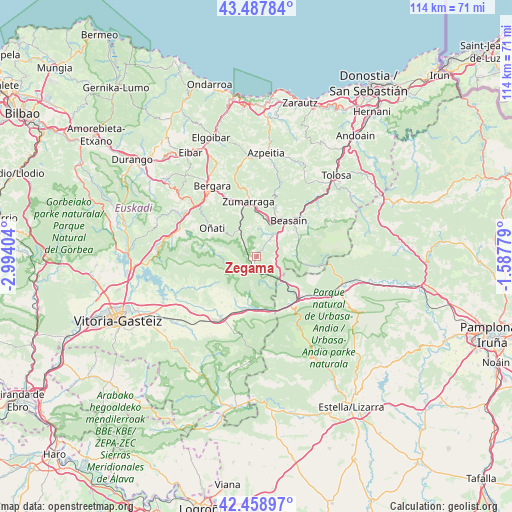
Zegama GPS coordinates[2]
42° 58' 32.016" North, 2° 17' 27.276" West
| Map corner | latitude | longitude |
|---|---|---|
| Upper-left | 43.48784°, | -2.99404° |
| Center: | 42.97556°, | -2.29091° |
| Lower-right: | 42.45897°, | -1.58779° |
| Map W x H: | 114.4×114.4 km | = 71.1×71.1mi |
| max Lat: | 43.74134° ⇑5.8% North |
| Zegama: | 42.97556° |
| min Lat: | ⇓94.2% South 27.64134° |
| min Long | Zegama | max Long |
| -18.00367° | -2.29091° | 4.2899° |
| W 63.6%⇐ | ⇒36.4% E |
Elevation
Elevation of Zegama is 301 m = 988 ft, and this is 297 m = 974 ft below average elevation for this country.
| Max E: |
1682 m = 5518 ft | 74.6% |
| Avg. | 598 m = 1962 ft | |
| Zegama | 301 m = 988 ft | |
Min E: |
0 m = 0 ft | 25.4% |
See also: Spain elevation on elevation.city.
Geographical zone
Zegama is located in North temperate zone (between Tropic of Cancer and the Arctic Circle). Distance of this Northern Tropic circle is 2172.5 km =1349.9 mi to South.| Distance of | km | miles | from Zegama |
|---|---|---|---|
| North Pole | 5228.6 | 3248.9 | to North |
| Arctic Circle | 2622.7 | 1629.7 | to North |
| Tropic Cancer | 2172.5 | 1349.9 | to South |
| Equator | 4778.4 | 2969.2 | to South |


Nearby cities:
15 places around Zegama: (largest is in red/bold)
• Araia
9.3 km =5.8 mi,  191°
191°
• Ataun
9.9 km =6.2 mi,  69°
69°
• Beasain
11.1 km =6.9 mi,  41°
41°
• Gabiria
8.3 km =5.2 mi,  6°
6°
• Idiazabal
6.2 km =3.9 mi,  49°
49°
• Lazkao
10.6 km =6.6 mi, 53°
• Legazpi
9.4 km =5.8 mi,  336°
336°
• Mutiloa
5.5 km =3.4 mi,  15°
15°
• Olaberria
9.1 km =5.7 mi, 51°
• Ormaiztegi
8 km =5 mi, 20°
• Oñati
11.6 km =7.2 mi,  303°
303°
• Segura
4.7 km =2.9 mi, 40°
• Zerain
4.4 km =2.7 mi, 19°
• Ziordia
12.7 km =7.9 mi,  156°
156°
• Zumarraga
12.7 km =7.9 mi,  351°
351°
Sources, notices
• [Note1] Compared only with cities in Spain existing in our database
• [Src1] Map data: © OpenStreetMap contributors (CC-BY-SA)
• [Src2] Other city data from geonames.org with taken over terms of usage.
• [Src3] Geographical zone / Annual Mean Temperature by Robert A. Rohde @ Wikipedia
