Almanza geodata
Almanza (Castille and León) is a seat of a third-order administrative division; located in Spain in Europe/Madrid (GMT+2) time zone. With population of 644 people, there are 3514 cities with bigger population in this country. Compared to other cities in Spain, 90.8% of cities are located further ↓South; 73% of cities are located further →East and 81.9% of cities have lower elevation than Almanza. Note1


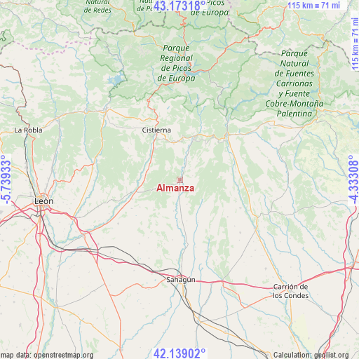
Almanza GPS coordinates[2]
42° 39' 29.7" North, 5° 2' 10.32" West
| Map corner | latitude | longitude |
|---|---|---|
| Upper-left | 43.17318°, | -5.73933° |
| Center: | 42.65825°, | -5.0362° |
| Lower-right: | 42.13902°, | -4.33308° |
| Map W x H: | 115×115 km | = 71.5×71.5mi |
| max Lat: | 43.74134° ⇑9.2% North |
| Almanza: | 42.65825° |
| min Lat: | ⇓90.8% South 27.64134° |
| min Long | Almanza | max Long |
| -18.00367° | -5.0362° | 4.2899° |
| W 27%⇐ | ⇒73% E |
Elevation
Elevation of Almanza is 916 m = 3005 ft, and this is 318 m = 1043 ft above average elevation for this country.
| Max E: |
1682 m = 5518 ft | 18.1% |
| Almanza | 916 m 3005 ft | |
| Avg. | 598 m = 1962 ft | |
Min E: |
0 m = 0 ft | 81.9% |
See also: Spain elevation on elevation.city.
Geographical zone
Almanza is located in North temperate zone (between Tropic of Cancer and the Arctic Circle). Distance of this Northern Tropic circle is 2137.2 km =1328 mi to South.| Distance of | km | miles | from Almanza |
|---|---|---|---|
| North Pole | 5263.9 | 3270.8 | to North |
| Arctic Circle | 2658 | 1651.6 | to North |
| Tropic Cancer | 2137.2 | 1328 | to South |
| Equator | 4743.2 | 2947.3 | to South |


Nearby cities:
15 places around Almanza: (largest is in red/bold)
• Cebanico
7.5 km =4.7 mi,  6°
6°
• Cistierna
17.8 km =11.1 mi,  335°
335°
• Cubillas de Rueda
11.4 km =7.1 mi,  268°
268°
• Fresno del Río
18.1 km =11.2 mi,  81°
81°
• Gradefes
16.1 km =10 mi,  256°
256°
• Mantinos
19 km =11.8 mi,  56°
56°
• Pino del Río
18.7 km =11.6 mi,  94°
94°
• Prado de la Guzpeña
13.9 km =8.6 mi,  3°
3°
• Valdepolo
17.9 km =11.1 mi,  239°
239°
• Valderrueda
18.9 km =11.7 mi,  22°
22°
• Villalba de Guardo
18.8 km =11.7 mi,  67°
67°
• Villamartín de Don Sancho
10.1 km =6.3 mi,  191°
191°
• Villaselán
10.9 km =6.8 mi, 185°
• Villazanzo de Valderaduey
14.8 km =9.2 mi,  156°
156°
• Villota del Páramo
19.3 km =12 mi,  127°
127°
Sources, notices
• [Note1] Compared only with cities in Spain existing in our database
• [Src1] Map data: © OpenStreetMap contributors (CC-BY-SA)
• [Src2] Other city data from geonames.org with taken over terms of usage.
• [Src3] Geographical zone / Annual Mean Temperature by Robert A. Rohde @ Wikipedia
