Aldeatejada geodata
Aldeatejada (Castille and León) is a seat of a third-order administrative division; located in Spain in Europe/Madrid (GMT+2) time zone. With population of 873 people, there are 3097 cities with bigger population in this country. Compared to other cities in Spain, 53.4% of cities are located further ↑North; 81.7% of cities are located further →East and 67.5% of cities have lower elevation than Aldeatejada. Note1
Administrative division(s):
- Level 1: Castille and León
- Level 2: Provincia de Salamanca
- Level 3: Aldeatejada


Aldeatejada GPS coordinates[2]
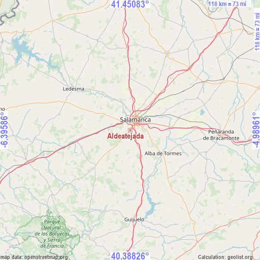
40° 55' 18.048" North, 5° 41' 33.828" West
| Map corner | latitude | longitude |
|---|---|---|
| Upper-left | 41.45083°, | -6.39586° |
| Center: | 40.92168°, | -5.69273° |
| Lower-right: | 40.38826°, | -4.98961° |
| Map W x H: | 118.1×118.1 km | = 73.4×73.4mi |
| max Lat: | 43.74134° ⇑53.4% North |
| Aldeatejada: | 40.92168° |
| min Lat: | ⇓46.6% South 27.64134° |
| min Long | Aldeatejada | max Long |
| -18.00367° | -5.69273° | 4.2899° |
| W 18.3%⇐ | ⇒81.7% E |
Elevation
Elevation of Aldeatejada is 795 m = 2608 ft, and this is 197 m = 646 ft above average elevation for this country.
| Max E: |
1682 m = 5518 ft | 32.5% |
| Aldeatejada | 795 m 2608 ft | |
| Avg. | 598 m = 1962 ft | |
Min E: |
0 m = 0 ft | 67.5% |
See also: Spain elevation on elevation.city.
Geographical zone
Aldeatejada is located in North temperate zone (between Tropic of Cancer and the Arctic Circle). Distance of this Northern Tropic circle is 1944.1 km =1208 mi to South.| Distance of | km | miles | from Aldeatejada |
|---|---|---|---|
| North Pole | 5457 | 3390.8 | to North |
| Arctic Circle | 2851.1 | 1771.6 | to North |
| Tropic Cancer | 1944.1 | 1208 | to South |
| Equator | 4550.1 | 2827.3 | to South |


Nearby cities:
15 places around Aldeatejada: (largest is in red/bold)
• Arapiles
5.1 km =3.2 mi,  127°
127°
• Cabrerizos
9.4 km =5.8 mi,  48°
48°
• Calvarrasa de Abajo
12.1 km =7.5 mi,  76°
76°
• Calvarrasa de Arriba
8.6 km =5.3 mi,  101°
101°
• Carbajosa de la Sagrada
3.8 km =2.4 mi,  70°
70°
• Carrascal de Barregas
8.6 km =5.3 mi,  317°
317°
• Doñinos de Salamanca
6 km =3.7 mi,  314°
314°
• Miranda de Azán
3.9 km =2.4 mi,  166°
166°
• Mozárbez
8 km =5 mi,  154°
154°
• Parada de Arriba
11.1 km =6.9 mi, 310°
• Pelabravo
9.7 km =6 mi, 80°
• Salamanca
5.8 km =3.6 mi,  24°
24°
• Santa Marta de Tormes
6.4 km =4 mi,  59°
59°
• Villamayor
8.6 km =5.3 mi,  358°
358°
• Villares de la Reina
10.3 km =6.4 mi, 20°
Sources, notices
• [Note1] Compared only with cities in Spain existing in our database
• [Src1] Map data: © OpenStreetMap contributors (CC-BY-SA)
• [Src2] Other city data from geonames.org with taken over terms of usage.
• [Src3] Geographical zone / Annual Mean Temperature by Robert A. Rohde @ Wikipedia
