Villamayor geodata
Villamayor (Castille and León) is a seat of a third-order administrative division; located in Spain in Europe/Madrid (GMT+2) time zone. With population of 4,538 people, there are 1378 cities with bigger population in this country. Compared to other cities in Spain, 51.6% of cities are located further ↑North; 81.7% of cities are located further →East and 66.2% of cities have lower elevation than Villamayor. Note1
Administrative division(s):
- Level 1: Castille and León
- Level 2: Provincia de Salamanca
- Level 3: Villamayor


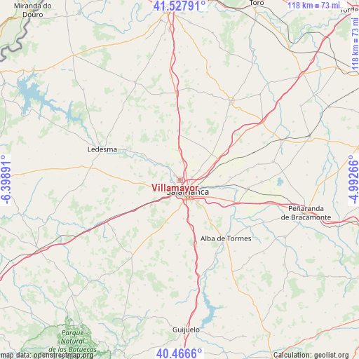
Villamayor GPS coordinates[2]
40° 59' 57.804" North, 5° 41' 44.844" West
| Map corner | latitude | longitude |
|---|---|---|
| Upper-left | 41.52791°, | -6.39891° |
| Center: | 40.99939°, | -5.69579° |
| Lower-right: | 40.4666°, | -4.99266° |
| Map W x H: | 118×118 km | = 73.3×73.3mi |
| max Lat: | 43.74134° ⇑51.6% North |
| Villamayor: | 40.99939° |
| min Lat: | ⇓48.4% South 27.64134° |
| min Long | Villamayor | max Long |
| -18.00367° | -5.69579° | 4.2899° |
| W 18.3%⇐ | ⇒81.7% E |
Elevation
Elevation of Villamayor is 786 m = 2579 ft, and this is 188 m = 617 ft above average elevation for this country.
| Max E: |
1682 m = 5518 ft | 33.8% |
| Villamayor | 786 m 2579 ft | |
| Avg. | 598 m = 1962 ft | |
Min E: |
0 m = 0 ft | 66.2% |
See also: Spain elevation on elevation.city.
Geographical zone
Villamayor is located in North temperate zone (between Tropic of Cancer and the Arctic Circle). Distance of this Northern Tropic circle is 1952.8 km =1213.4 mi to South.| Distance of | km | miles | from Villamayor |
|---|---|---|---|
| North Pole | 5448.4 | 3385.5 | to North |
| Arctic Circle | 2842.5 | 1766.2 | to North |
| Tropic Cancer | 1952.8 | 1213.4 | to South |
| Equator | 4558.7 | 2832.6 | to South |


Nearby cities:
15 places around Villamayor: (largest is in red/bold)
• Aldeatejada
8.6 km =5.3 mi,  178°
178°
• Cabrerizos
7.7 km =4.8 mi,  108°
108°
• Carbajosa de la Sagrada
8.3 km =5.2 mi,  152°
152°
• Carrascal de Barregas
6 km =3.7 mi,  247°
247°
• Castellanos de Moriscos
9.1 km =5.7 mi,  76°
76°
• Castellanos de Villiquera
5.8 km =3.6 mi,  0°
0°
• Doñinos de Salamanca
6 km =3.7 mi,  222°
222°
• Florida de Liébana
6.2 km =3.9 mi,  295°
295°
• Monterrubio de Armuña
5.3 km =3.3 mi,  55°
55°
• Parada de Arriba
8.3 km =5.2 mi,  260°
260°
• Salamanca
4.3 km =2.7 mi,  141°
141°
• San Cristóbal de la Cuesta
7.3 km =4.5 mi, 63°
• Santa Marta de Tormes
7.9 km =4.9 mi,  133°
133°
• Valverdón
8.1 km =5 mi,  310°
310°
• Villares de la Reina
4.1 km =2.5 mi, 75°
Sources, notices
• [Note1] Compared only with cities in Spain existing in our database
• [Src1] Map data: © OpenStreetMap contributors (CC-BY-SA)
• [Src2] Other city data from geonames.org with taken over terms of usage.
• [Src3] Geographical zone / Annual Mean Temperature by Robert A. Rohde @ Wikipedia
