Ahigal de Villarino geodata
Ahigal de Villarino (Castille and León) is a seat of a third-order administrative division; located in Spain in Europe/Madrid (GMT+2) time zone. With population of 42 people, there are 6543 cities with bigger population in this country. Compared to other cities in Spain, 52.2% of cities are located further ↓South; 90.2% of cities are located further →East and 63.2% of cities have lower elevation than Ahigal de Villarino. Note1
Administrative division(s):
- Level 1: Castille and León
- Level 2: Provincia de Salamanca
- Level 3: Ahigal de Villarino


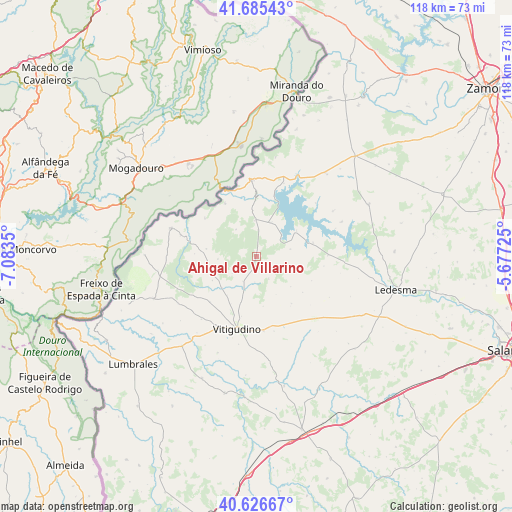
Ahigal de Villarino GPS coordinates[2]
41° 9' 29.484" North, 6° 22' 49.332" West
| Map corner | latitude | longitude |
|---|---|---|
| Upper-left | 41.68543°, | -7.0835° |
| Center: | 41.15819°, | -6.38037° |
| Lower-right: | 40.62667°, | -5.67725° |
| Map W x H: | 117.7×117.7 km | = 73.1×73.1mi |
| max Lat: | 43.74134° ⇑47.8% North |
| Ahigal de Villarino: | 41.15819° |
| min Lat: | ⇓52.2% South 27.64134° |
| min Long | Ahigal de Villa | max Long |
| -18.00367° | -6.38037° | 4.2899° |
| W 9.8%⇐ | ⇒90.2% E |
Elevation
Elevation of Ahigal de Villarino is 766 m = 2513 ft, and this is 168 m = 551 ft above average elevation for this country.
| Max E: |
1682 m = 5518 ft | 36.8% |
| Ahigal de Villarino | 766 m 2513 ft | |
| Avg. | 598 m = 1962 ft | |
Min E: |
0 m = 0 ft | 63.2% |
See also: Spain elevation on elevation.city.
Geographical zone
Ahigal de Villarino is located in North temperate zone (between Tropic of Cancer and the Arctic Circle). Distance of this Northern Tropic circle is 1970.4 km =1224.3 mi to South.| Distance of | km | miles | from Ahigal de Villarino |
|---|---|---|---|
| North Pole | 5430.7 | 3374.5 | to North |
| Arctic Circle | 2824.8 | 1755.2 | to North |
| Tropic Cancer | 1970.4 | 1224.3 | to South |
| Equator | 4576.4 | 2843.6 | to South |


Nearby cities:
15 places around Ahigal de Villarino: (largest is in red/bold)
• Almendra
8.6 km =5.3 mi,  22°
22°
• Barceo
12.3 km =7.6 mi,  208°
208°
• Brincones
5.6 km =3.5 mi,  151°
151°
• Espadaña
13.5 km =8.4 mi,  143°
143°
• Iruelos
4.8 km =3 mi,  113°
113°
• Monleras
13.3 km =8.3 mi,  76°
76°
• Puertas
10.3 km =6.4 mi,  131°
131°
• Sanchón de la Ribera
8.2 km =5.1 mi,  199°
199°
• Sardón de los Frailes
11 km =6.8 mi,  55°
55°
• Trabanca
8.3 km =5.2 mi,  357°
357°
• Valderrodrigo
14.9 km =9.3 mi,  226°
226°
• Valsalabroso
11.6 km =7.2 mi,  242°
242°
• Villar de Samaniego
6.4 km =4 mi,  223°
223°
• Villarino de los Aires
14.5 km =9 mi,  329°
329°
• Villarmuerto
11.4 km =7.1 mi,  172°
172°
Sources, notices
• [Note1] Compared only with cities in Spain existing in our database
• [Src1] Map data: © OpenStreetMap contributors (CC-BY-SA)
• [Src2] Other city data from geonames.org with taken over terms of usage.
• [Src3] Geographical zone / Annual Mean Temperature by Robert A. Rohde @ Wikipedia
