Horta-Guinardó geodata
Horta-Guinardó (Catalonia) is a section of populated place; located in Spain in Europe/Madrid (GMT+2) time zone. With population of 168,092 people, there are 46 cities with bigger population in this country. Compared to other cities in Spain, 58.5% of cities are located further ↓South; 94.7% of cities are located further ←West and 83.2% of cities have higher elevation than Horta-Guinardó. Note1
Administrative division(s):
- Level 1: Catalonia
- Level 2: Província de Barcelona
- Level 3: Barcelona
- Level 4: Horta-Guinardó


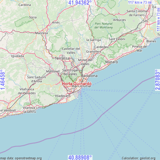
Horta-Guinardó GPS coordinates[2]
41° 25' 6.564" North, 2° 10' 3.72" East
| Map corner | latitude | longitude |
|---|---|---|
| Upper-left | 41.94362°, | 1.46458° |
| Center: | 41.41849°, | 2.1677° |
| Lower-right: | 40.88908°, | 2.87083° |
| Map W x H: | 117.3×117.3 km | = 72.9×72.9mi |
| max Lat: | 43.74134° ⇑41.5% North |
| Horta-Guinardó: | 41.41849° |
| min Lat: | ⇓58.5% South 27.64134° |
| min Long | Horta-Guinardó | max Long |
| -18.00367° | 2.1677° | 4.2899° |
| W 94.7%⇐ | ⇒5.3% E |
Elevation
Elevation of Horta-Guinardó is 166 m = 545 ft, and this is 432 m = 1417 ft below average elevation for this country.
| Max E: |
1682 m = 5518 ft | 83.2% |
| Avg. | 598 m = 1962 ft | |
| Horta-Guinardó | 166 m = 545 ft | |
Min E: |
0 m = 0 ft | 16.8% |
See also: Horta-Guinardó elevation on elevation.city.
Geographical zone
Horta-Guinardó is located in North temperate zone (between Tropic of Cancer and the Arctic Circle). Distance of this Northern Tropic circle is 1999.4 km =1242.4 mi to South.| Distance of | km | miles | from Horta-Guinardó |
|---|---|---|---|
| North Pole | 5401.8 | 3356.5 | to North |
| Arctic Circle | 2795.9 | 1737.3 | to North |
| Tropic Cancer | 1999.4 | 1242.4 | to South |
| Equator | 4605.3 | 2861.6 | to South |


Nearby cities:
15 places around Horta-Guinardó: (largest is in red/bold)
• Can Baró
0.5 km =0.3 mi,  246°
246°
• El Carmel
0.7 km =0.4 mi,  261°
261°
• La Sagrera
1.6 km =1 mi,  72°
72°
• Navas
1.5 km =0.9 mi,  91°
91°
• Sagrada Família
1.7 km =1.1 mi,  163°
163°
• Vilapicina i la Torre Llobeta
1.2 km =0.7 mi,  25°
25°
• el Baix Guinardó
0.7 km =0.4 mi,  179°
179°
• el Camp d'en Grassot i Gràcia Nova
1.4 km =0.9 mi,  189°
189°
• el Camp de l'Arpa del Clot
1.4 km =0.9 mi,  120°
120°
• el Coll
1.7 km =1.1 mi,  265°
265°
• el Congrés i els Indians
1.3 km =0.8 mi,  58°
58°
• el Guinardó
0.5 km =0.3 mi, 85°
• el Turó de la Peira
1.5 km =0.9 mi,  3°
3°
• la Font d'en Fargues
0.7 km =0.4 mi,  343°
343°
• la Salut
1.3 km =0.8 mi,  238°
238°
Sources, notices
• [Note1] Compared only with cities in Spain existing in our database
• [Src1] Map data: © OpenStreetMap contributors (CC-BY-SA)
• [Src2] Other city data from geonames.org with taken over terms of usage.
• [Src3] Geographical zone / Annual Mean Temperature by Robert A. Rohde @ Wikipedia
