Pego geodata
Pego (Valencia) is a seat of a third-order administrative division; located in Spain in Europe/Madrid (GMT+2) time zone. With population of 11,133 people, there are 794 cities with bigger population in this country. Compared to other cities in Spain, 82.8% of cities are located further ↑North; 86.3% of cities are located further ←West and 89.1% of cities have higher elevation than Pego. Note1


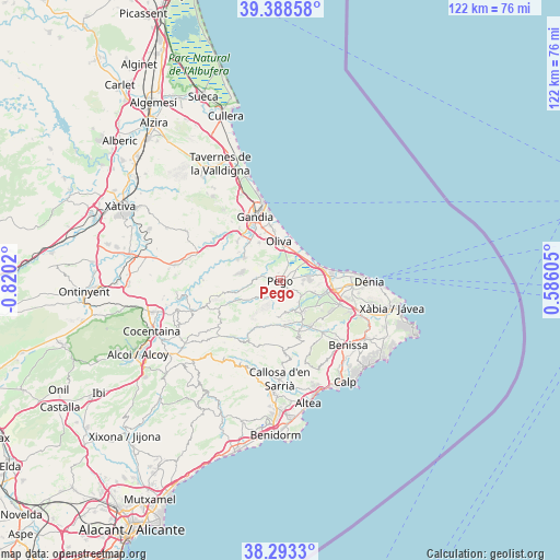
Pego GPS coordinates[2]
38° 50' 34.98" North, 0° 7' 1.452" West
| Map corner | latitude | longitude |
|---|---|---|
| Upper-left | 39.38858°, | -0.8202° |
| Center: | 38.84305°, | -0.11707° |
| Lower-right: | 38.2933°, | 0.58605° |
| Map W x H: | 121.8×121.8 km | = 75.7×75.7mi |
| max Lat: | 43.74134° ⇑82.8% North |
| Pego: | 38.84305° |
| min Lat: | ⇓17.2% South 27.64134° |
| min Long | Pego | max Long |
| -18.00367° | -0.11707° | 4.2899° |
| W 86.3%⇐ | ⇒13.7% E |
Elevation
Elevation of Pego is 80 m = 262 ft, and this is 518 m = 1699 ft below average elevation for this country.
| Max E: |
1682 m = 5518 ft | 89.1% |
| Avg. | 598 m = 1962 ft | |
| Pego | 80 m = 262 ft | |
Min E: |
0 m = 0 ft | 10.9% |
See also: Spain elevation on elevation.city.
Geographical zone
Pego is located in North temperate zone (between Tropic of Cancer and the Arctic Circle). Distance of this Northern Tropic circle is 1713 km =1064.4 mi to South.| Distance of | km | miles | from Pego |
|---|---|---|---|
| North Pole | 5688.1 | 3534.4 | to North |
| Arctic Circle | 3082.2 | 1915.2 | to North |
| Tropic Cancer | 1713 | 1064.4 | to South |
| Equator | 4318.9 | 2683.6 | to South |


Nearby cities:
15 places around Pego: (largest is in red/bold)
• Adsubia
3.2 km =2 mi,  280°
280°
• Beniarbeig
10.2 km =6.3 mi,  103°
103°
• Benichembla
9.8 km =6.1 mi,  175°
175°
• Benidoleig
9.4 km =5.8 mi,  126°
126°
• Benimeli
6.8 km =4.2 mi,  108°
108°
• L'Alqueria de la Comtessa
10.4 km =6.5 mi,  344°
344°
• Murla
9.7 km =6 mi,  161°
161°
• Oliva
8.5 km =5.3 mi,  358°
358°
• Orba
8.4 km =5.2 mi,  145°
145°
• Ráfol de Almunia
6.2 km =3.9 mi, 113°
• Sagra
5.7 km =3.5 mi, 128°
• Sanet y Negrals
7.6 km =4.7 mi, 109°
• Tormos
6.1 km =3.8 mi,  139°
139°
• Vall de Ebo
5.5 km =3.4 mi,  221°
221°
• Villalonga
9.2 km =5.7 mi,  301°
301°
Sources, notices
• [Note1] Compared only with cities in Spain existing in our database
• [Src1] Map data: © OpenStreetMap contributors (CC-BY-SA)
• [Src2] Other city data from geonames.org with taken over terms of usage.
• [Src3] Geographical zone / Annual Mean Temperature by Robert A. Rohde @ Wikipedia
