Benidoleig geodata
Benidoleig (Valencia) is a seat of a third-order administrative division; located in Spain in Europe/Madrid (GMT+2) time zone. With population of 1,021 people, there are 2909 cities with bigger population in this country. Compared to other cities in Spain, 83.3% of cities are located further ↑North; 86.9% of cities are located further ←West and 86.9% of cities have higher elevation than Benidoleig. Note1


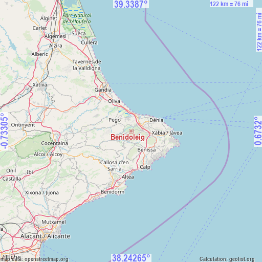
Benidoleig GPS coordinates[2]
38° 47' 34.008" North, 0° 1' 47.712" West
| Map corner | latitude | longitude |
|---|---|---|
| Upper-left | 39.3387°, | -0.73305° |
| Center: | 38.79278°, | -0.02992° |
| Lower-right: | 38.24265°, | 0.6732° |
| Map W x H: | 121.9×121.9 km | = 75.7×75.7mi |
| max Lat: | 43.74134° ⇑83.3% North |
| Benidoleig: | 38.79278° |
| min Lat: | ⇓16.7% South 27.64134° |
| min Long | Benidoleig | max Long |
| -18.00367° | -0.02992° | 4.2899° |
| W 86.9%⇐ | ⇒13.1% E |
Elevation
Elevation of Benidoleig is 111 m = 364 ft, and this is 487 m = 1598 ft below average elevation for this country.
| Max E: |
1682 m = 5518 ft | 86.9% |
| Avg. | 598 m = 1962 ft | |
| Benidoleig | 111 m = 364 ft | |
Min E: |
0 m = 0 ft | 13.1% |
See also: Spain elevation on elevation.city.
Geographical zone
Benidoleig is located in North temperate zone (between Tropic of Cancer and the Arctic Circle). Distance of this Northern Tropic circle is 1707.4 km =1060.9 mi to South.| Distance of | km | miles | from Benidoleig |
|---|---|---|---|
| North Pole | 5693.7 | 3537.9 | to North |
| Arctic Circle | 3087.8 | 1918.7 | to North |
| Tropic Cancer | 1707.4 | 1060.9 | to South |
| Equator | 4313.4 | 2680.2 | to South |


Nearby cities:
15 places around Benidoleig: (largest is in red/bold)
• Alcalalí
4.8 km =3 mi,  190°
190°
• Beniarbeig
4.1 km =2.5 mi,  36°
36°
• Benichembla
8 km =5 mi,  238°
238°
• Benimeli
3.6 km =2.2 mi,  342°
342°
• Jalón
6 km =3.7 mi,  164°
164°
• Murla
5.8 km =3.6 mi,  231°
231°
• Ondara
5.7 km =3.5 mi,  46°
46°
• Orba
3.2 km =2 mi, 244°
• Parcent
6.1 km =3.8 mi,  209°
209°
• Pedreguer
5.5 km =3.4 mi,  89°
89°
• Ráfol de Almunia
3.7 km =2.3 mi,  329°
329°
• Sagra
3.7 km =2.3 mi,  303°
303°
• Sanet y Negrals
3 km =1.9 mi,  353°
353°
• Tormos
3.7 km =2.3 mi,  284°
284°
• Vergel
7 km =4.3 mi,  30°
30°
Sources, notices
• [Note1] Compared only with cities in Spain existing in our database
• [Src1] Map data: © OpenStreetMap contributors (CC-BY-SA)
• [Src2] Other city data from geonames.org with taken over terms of usage.
• [Src3] Geographical zone / Annual Mean Temperature by Robert A. Rohde @ Wikipedia
