Sanet y Negrals geodata
Sanet y Negrals (Valencia) is a seat of a third-order administrative division; located in Spain in Europe/Madrid (GMT+2) time zone. With population of 642 people, there are 3519 cities with bigger population in this country. Compared to other cities in Spain, 83.1% of cities are located further ↑North; 86.8% of cities are located further ←West and 88.1% of cities have higher elevation than Sanet y Negrals. Note1
Administrative division(s):
- Level 1: Valencia
- Level 2: Provincia de Alicante
- Level 3: Sanet y Negrals


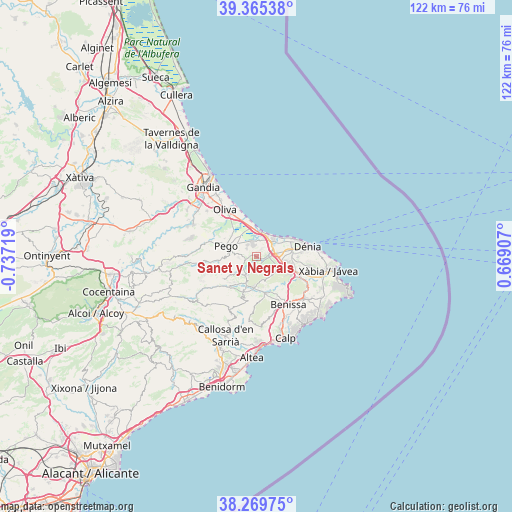
Sanet y Negrals GPS coordinates[2]
38° 49' 10.812" North, 0° 2' 2.616" West
| Map corner | latitude | longitude |
|---|---|---|
| Upper-left | 39.36538°, | -0.73719° |
| Center: | 38.81967°, | -0.03406° |
| Lower-right: | 38.26975°, | 0.66907° |
| Map W x H: | 121.8×121.8 km | = 75.7×75.7mi |
| max Lat: | 43.74134° ⇑83.1% North |
| Sanet y Negrals: | 38.81967° |
| min Lat: | ⇓16.9% South 27.64134° |
| min Long | Sanet y Negrals | max Long |
| -18.00367° | -0.03406° | 4.2899° |
| W 86.8%⇐ | ⇒13.2% E |
Elevation
Elevation of Sanet y Negrals is 94 m = 308 ft, and this is 504 m = 1654 ft below average elevation for this country.
| Max E: |
1682 m = 5518 ft | 88.1% |
| Avg. | 598 m = 1962 ft | |
| Sanet y Negrals | 94 m = 308 ft | |
Min E: |
0 m = 0 ft | 11.9% |
See also: Spain elevation on elevation.city.
Geographical zone
Sanet y Negrals is located in North temperate zone (between Tropic of Cancer and the Arctic Circle). Distance of this Northern Tropic circle is 1710.4 km =1062.8 mi to South.| Distance of | km | miles | from Sanet y Negrals |
|---|---|---|---|
| North Pole | 5690.7 | 3536 | to North |
| Arctic Circle | 3084.8 | 1916.8 | to North |
| Tropic Cancer | 1710.4 | 1062.8 | to South |
| Equator | 4316.3 | 2682 | to South |


Nearby cities:
15 places around Sanet y Negrals: (largest is in red/bold)
• Alcalalí
7.7 km =4.8 mi,  183°
183°
• Beniarbeig
2.8 km =1.7 mi,  83°
83°
• Benidoleig
3 km =1.9 mi,  173°
173°
• Benimeli
0.8 km =0.5 mi,  301°
301°
• Murla
7.8 km =4.8 mi,  212°
212°
• Ondara
4.5 km =2.8 mi, 77°
• Orba
5 km =3.1 mi, 209°
• Parcent
8.7 km =5.4 mi,  197°
197°
• Pedreguer
6.6 km =4.1 mi,  116°
116°
• Pego
7.6 km =4.7 mi,  289°
289°
• Ráfol de Almunia
1.5 km =0.9 mi,  276°
276°
• Sagra
2.9 km =1.8 mi,  250°
250°
• Tormos
3.8 km =2.4 mi,  238°
238°
• Vergel
4.9 km =3 mi,  51°
51°
• els Poblets
6.1 km =3.8 mi, 51°
Sources, notices
• [Note1] Compared only with cities in Spain existing in our database
• [Src1] Map data: © OpenStreetMap contributors (CC-BY-SA)
• [Src2] Other city data from geonames.org with taken over terms of usage.
• [Src3] Geographical zone / Annual Mean Temperature by Robert A. Rohde @ Wikipedia
