Montbau geodata
Montbau (Catalonia) is a section of populated place; located in Spain in Europe/Madrid (GMT+2) time zone. With population of 5,110 people, there are 1277 cities with bigger population in this country. Compared to other cities in Spain, 59.1% of cities are located further ↓South; 94.1% of cities are located further ←West and 78.3% of cities have higher elevation than Montbau. Note1
Administrative division(s):
- Level 1: Catalonia
- Level 2: Província de Barcelona
- Level 3: Barcelona
- Level 4: Horta-Guinardó


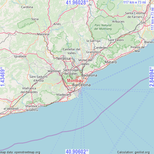
Montbau GPS coordinates[2]
41° 26' 7.044" North, 2° 8' 16.116" East
| Map corner | latitude | longitude |
|---|---|---|
| Upper-left | 41.96028°, | 1.43469° |
| Center: | 41.43529°, | 2.13781° |
| Lower-right: | 40.90602°, | 2.84094° |
| Map W x H: | 117.2×117.2 km | = 72.8×72.8mi |
| max Lat: | 43.74134° ⇑40.9% North |
| Montbau: | 41.43529° |
| min Lat: | ⇓59.1% South 27.64134° |
| min Long | Montbau | max Long |
| -18.00367° | 2.13781° | 4.2899° |
| W 94.1%⇐ | ⇒5.9% E |
Elevation
Elevation of Montbau is 250 m = 820 ft, and this is 348 m = 1142 ft below average elevation for this country.
| Max E: |
1682 m = 5518 ft | 78.3% |
| Avg. | 598 m = 1962 ft | |
| Montbau | 250 m = 820 ft | |
Min E: |
0 m = 0 ft | 21.7% |
See also: Spain elevation on elevation.city.
Geographical zone
Montbau is located in North temperate zone (between Tropic of Cancer and the Arctic Circle). Distance of this Northern Tropic circle is 2001.3 km =1243.5 mi to South.| Distance of | km | miles | from Montbau |
|---|---|---|---|
| North Pole | 5399.9 | 3355.3 | to North |
| Arctic Circle | 2794 | 1736.1 | to North |
| Tropic Cancer | 2001.3 | 1243.5 | to South |
| Equator | 4607.2 | 2862.8 | to South |


Nearby cities:
15 places around Montbau: (largest is in red/bold)
• Can Baró
2.9 km =1.8 mi,  135°
135°
• Can Peguera
2.4 km =1.5 mi,  91°
91°
• Canyelles
2.4 km =1.5 mi,  62°
62°
• El Carmel
2.7 km =1.7 mi, 137°
• Horta
1.6 km =1 mi, 86°
• Sant Genís dels Agudells
1.3 km =0.8 mi,  210°
210°
• Vallcarca
2.6 km =1.6 mi,  168°
168°
• el Coll
2.2 km =1.4 mi,  158°
158°
• el Turó de la Peira
2.6 km =1.6 mi,  97°
97°
• la Clota
1.5 km =0.9 mi,  119°
119°
• la Font d'en Fargues
2.6 km =1.6 mi, 117°
• la Guineueta
2.6 km =1.6 mi,  81°
81°
• la Salut
2.9 km =1.8 mi,  151°
151°
• la Teixonera
1.5 km =0.9 mi, 151°
• la Vall d'Hebron
1 km =0.6 mi, 121°
Sources, notices
• [Note1] Compared only with cities in Spain existing in our database
• [Src1] Map data: © OpenStreetMap contributors (CC-BY-SA)
• [Src2] Other city data from geonames.org with taken over terms of usage.
• [Src3] Geographical zone / Annual Mean Temperature by Robert A. Rohde @ Wikipedia
