la Vall d'Hebron geodata
la Vall d'Hebron (Catalonia) is a section of populated place; located in Spain in Europe/Madrid (GMT+2) time zone. With population of 5,469 people, there are 1221 cities with bigger population in this country. Compared to other cities in Spain, 58.9% of cities are located further ↓South; 94.3% of cities are located further ←West and 85.9% of cities have higher elevation than la Vall d'Hebron. Note1
Administrative division(s):
- Level 1: Catalonia
- Level 2: Província de Barcelona
- Level 3: Barcelona
- Level 4: Horta-Guinardó


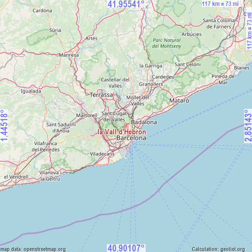
la Vall d'Hebron GPS coordinates[2]
41° 25' 49.368" North, 2° 8' 53.88" East
| Map corner | latitude | longitude |
|---|---|---|
| Upper-left | 41.95541°, | 1.44518° |
| Center: | 41.43038°, | 2.1483° |
| Lower-right: | 40.90107°, | 2.85143° |
| Map W x H: | 117.2×117.2 km | = 72.8×72.8mi |
| max Lat: | 43.74134° ⇑41.1% North |
| la Vall d'Hebron: | 41.43038° |
| min Lat: | ⇓58.9% South 27.64134° |
| min Long | la Vall d'Hebro | max Long |
| -18.00367° | 2.1483° | 4.2899° |
| W 94.3%⇐ | ⇒5.7% E |
Elevation
Elevation of la Vall d'Hebron is 126 m = 413 ft, and this is 472 m = 1549 ft below average elevation for this country.
| Max E: |
1682 m = 5518 ft | 85.9% |
| Avg. | 598 m = 1962 ft | |
| la Vall d'Hebron | 126 m = 413 ft | |
Min E: |
0 m = 0 ft | 14.1% |
See also: Spain elevation on elevation.city.
Geographical zone
la Vall d'Hebron is located in North temperate zone (between Tropic of Cancer and the Arctic Circle). Distance of this Northern Tropic circle is 2000.7 km =1243.2 mi to South.| Distance of | km | miles | from la Vall d'Hebron |
|---|---|---|---|
| North Pole | 5400.4 | 3355.7 | to North |
| Arctic Circle | 2794.5 | 1736.4 | to North |
| Tropic Cancer | 2000.7 | 1243.2 | to South |
| Equator | 4606.6 | 2862.4 | to South |


Nearby cities:
15 places around la Vall d'Hebron: (largest is in red/bold)
• Can Baró
1.9 km =1.2 mi,  142°
142°
• Can Peguera
1.6 km =1 mi,  71°
71°
• Canyelles
2.1 km =1.3 mi,  37°
37°
• El Carmel
1.7 km =1.1 mi,  147°
147°
• Horta
1 km =0.6 mi,  48°
48°
• Horta-Guinardó
2.1 km =1.3 mi,  129°
129°
• Montbau
1 km =0.6 mi,  301°
301°
• Sant Genís dels Agudells
1.6 km =1 mi,  249°
249°
• el Coll
1.5 km =0.9 mi,  183°
183°
• el Turó de la Peira
1.7 km =1.1 mi,  82°
82°
• la Clota
0.4 km =0.2 mi,  112°
112°
• la Font d'en Fargues
1.6 km =1 mi, 114°
• la Guineueta
2 km =1.2 mi,  61°
61°
• la Salut
2.1 km =1.3 mi,  165°
165°
• la Teixonera
0.8 km =0.5 mi,  190°
190°
Sources, notices
• [Note1] Compared only with cities in Spain existing in our database
• [Src1] Map data: © OpenStreetMap contributors (CC-BY-SA)
• [Src2] Other city data from geonames.org with taken over terms of usage.
• [Src3] Geographical zone / Annual Mean Temperature by Robert A. Rohde @ Wikipedia
