Turku geodata
Turku (Southwest Finland) is a seat of a first-order administrative division; located in Finland in Europe/Helsinki (GMT+3) time zone. With population of 175,945 people, there are 4 cities with bigger population in this country. Compared to other cities in Finland, 88.2% of cities are located further ↑North; 87% of cities are located further →East and 78% of cities have higher elevation than Turku. Note1


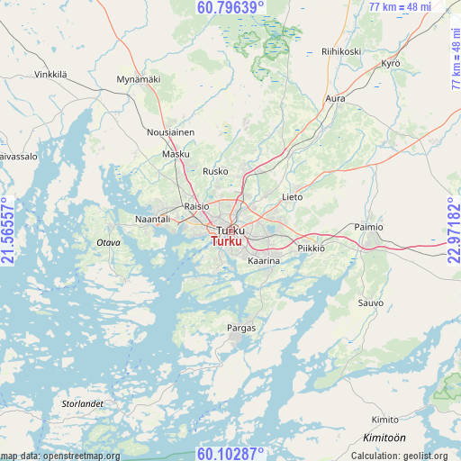
Turku GPS coordinates[2]
60° 27' 5.328" North, 22° 16' 7.284" East
| Map corner | latitude | longitude |
|---|---|---|
| Upper-left | 60.79639°, | 21.56557° |
| Center: | 60.45148°, | 22.26869° |
| Lower-right: | 60.10287°, | 22.97182° |
| Map W x H: | 77.1×77.1 km | = 47.9×47.9mi |
| max Lat: | 69.90864° ⇑88.2% North |
| Turku: | 60.45148° |
| min Lat: | ⇓11.8% South 59.83333° |
| min Long | Turku | max Long |
| 21.2° | 22.26869° | 30.93276° |
| W 13%⇐ | ⇒87% E |
Elevation
Elevation of Turku is 22 m = 72 ft, and this is 55.1 m = 181 ft below average elevation for this country.
| Max E: |
299 m = 981 ft | 78% |
| Avg. | 77.1 m = 253 ft | |
| Turku | 22 m = 72 ft | |
Min E: |
1 m = 3 ft | 22% |
See also: Turku elevation on elevation.city.
Geographical zone
Turku is located in North temperate zone (between Tropic of Cancer and the Arctic Circle). Distance of this North polar circle is 679.6 km =422.3 mi to North.| Distance of | km | miles | from Turku |
|---|---|---|---|
| North Pole | 3285.5 | 2041.5 | to North |
| Arctic Circle | 679.6 | 422.3 | to North |
| Tropic Cancer | 4115.7 | 2557.4 | to South |
| Equator | 6721.6 | 4176.6 | to South |


Nearby cities:
15 places around Turku: (largest is in red/bold)
• Kaarina
7.4 km =4.6 mi,  131°
131°
• Lemu
20.9 km =13 mi,  307°
307°
• Lieto
12.4 km =7.7 mi,  58°
58°
• Masku
16.2 km =10.1 mi,  324°
324°
• Merimasku
22.3 km =13.9 mi,  279°
279°
• Naantali
13.5 km =8.4 mi, 277°
• Nousiainen
19.9 km =12.4 mi,  328°
328°
• Paimio
22.9 km =14.2 mi,  88°
88°
• Pargas
16.2 km =10.1 mi,  173°
173°
• Piikkiö
13.9 km =8.6 mi,  102°
102°
• Raisio
6.7 km =4.2 mi, 305°
• Rusko
9.5 km =5.9 mi,  342°
342°
• Rymättylä
19.8 km =12.3 mi,  245°
245°
• Vahto
16.6 km =10.3 mi,  5°
5°
• Väståboland
17 km =10.6 mi, 174°
Sources, notices
• [Note1] Compared only with cities in Finland existing in our database
• [Src1] Map data: © OpenStreetMap contributors (CC-BY-SA)
• [Src2] Other city data from geonames.org with taken over terms of usage.
• [Src3] Geographical zone / Annual Mean Temperature by Robert A. Rohde @ Wikipedia
