Vahto geodata
Vahto (Southwest Finland) is a seat of a third-order administrative division; located in Finland in Europe/Helsinki (GMT+3) time zone. With population of 1,916 people, there are 364 cities with bigger population in this country. Compared to other cities in Finland, 81% of cities are located further ↑North; 86.8% of cities are located further →East and 74.6% of cities have higher elevation than Vahto. Note1


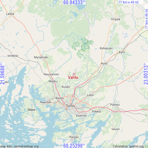
Vahto GPS coordinates[2]
60° 36' 0" North, 22° 18' 0" East
| Map corner | latitude | longitude |
|---|---|---|
| Upper-left | 60.94333°, | 21.59688° |
| Center: | 60.6°, | 22.3° |
| Lower-right: | 60.25298°, | 23.00313° |
| Map W x H: | 76.8×76.8 km | = 47.7×47.7mi |
| max Lat: | 69.90864° ⇑81% North |
| Vahto: | 60.6° |
| min Lat: | ⇓19% South 59.83333° |
| min Long | Vahto | max Long |
| 21.2° | 22.3° | 30.93276° |
| W 13.2%⇐ | ⇒86.8% E |
Elevation
Elevation of Vahto is 30 m = 98 ft, and this is 47.1 m = 155 ft below average elevation for this country.
| Max E: |
299 m = 981 ft | 74.6% |
| Avg. | 77.1 m = 253 ft | |
| Vahto | 30 m = 98 ft | |
Min E: |
1 m = 3 ft | 25.4% |
See also: Finland elevation on elevation.city.
Geographical zone
Vahto is located in North temperate zone (between Tropic of Cancer and the Arctic Circle). Distance of this North polar circle is 663.1 km =412 mi to North.| Distance of | km | miles | from Vahto |
|---|---|---|---|
| North Pole | 3269 | 2031.3 | to North |
| Arctic Circle | 663.1 | 412 | to North |
| Tropic Cancer | 4132.2 | 2567.6 | to South |
| Equator | 6738.1 | 4186.9 | to South |


Nearby cities:
15 places around Vahto: (largest is in red/bold)
• Askainen
24 km =14.9 mi,  261°
261°
• Aura
16.5 km =10.3 mi,  71°
71°
• Kaarina
21.8 km =13.5 mi,  169°
169°
• Lemu
18.6 km =11.6 mi, 258°
• Lieto
13.3 km =8.3 mi,  138°
138°
• Masku
11.5 km =7.1 mi,  253°
253°
• Mietoinen
20.3 km =12.6 mi,  280°
280°
• Mynämäki
18.9 km =11.7 mi,  297°
297°
• Naantali
21.1 km =13.1 mi,  225°
225°
• Nousiainen
12.1 km =7.5 mi,  272°
272°
• Piikkiö
22.8 km =14.2 mi,  148°
148°
• Raisio
14.6 km =9.1 mi,  209°
209°
• Rusko
8.7 km =5.4 mi, 211°
• Tarvasjoki
23.7 km =14.7 mi,  94°
94°
• Turku
16.6 km =10.3 mi,  185°
185°
Sources, notices
• [Note1] Compared only with cities in Finland existing in our database
• [Src1] Map data: © OpenStreetMap contributors (CC-BY-SA)
• [Src2] Other city data from geonames.org with taken over terms of usage.
• [Src3] Geographical zone / Annual Mean Temperature by Robert A. Rohde @ Wikipedia
