Naantali geodata
Naantali (Southwest Finland) is a seat of a third-order administrative division; located in Finland in Europe/Helsinki (GMT+3) time zone. With population of 13,607 people, there are 82 cities with bigger population in this country. Compared to other cities in Finland, 86.5% of cities are located further ↑North; 90% of cities are located further →East and 93.4% of cities have higher elevation than Naantali. Note1


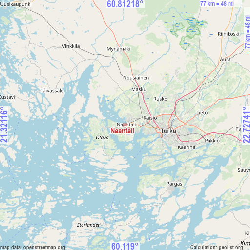
Naantali GPS coordinates[2]
60° 28' 2.784" North, 22° 1' 27.408" East
| Map corner | latitude | longitude |
|---|---|---|
| Upper-left | 60.81218°, | 21.32116° |
| Center: | 60.46744°, | 22.02428° |
| Lower-right: | 60.119°, | 22.72741° |
| Map W x H: | 77.1×77.1 km | = 47.9×47.9mi |
| max Lat: | 69.90864° ⇑86.5% North |
| Naantali: | 60.46744° |
| min Lat: | ⇓13.5% South 59.83333° |
| min Long | Naantali | max Long |
| 21.2° | 22.02428° | 30.93276° |
| W 10%⇐ | ⇒90% E |
Elevation
Elevation of Naantali is 9 m = 30 ft, and this is 68.1 m = 223 ft below average elevation for this country.
| Max E: |
299 m = 981 ft | 93.4% |
| Avg. | 77.1 m = 253 ft | |
| Naantali | 9 m = 30 ft | |
Min E: |
1 m = 3 ft | 6.6% |
See also: Finland elevation on elevation.city.
Geographical zone
Naantali is located in North temperate zone (between Tropic of Cancer and the Arctic Circle). Distance of this North polar circle is 677.8 km =421.2 mi to North.| Distance of | km | miles | from Naantali |
|---|---|---|---|
| North Pole | 3283.7 | 2040.4 | to North |
| Arctic Circle | 677.8 | 421.2 | to North |
| Tropic Cancer | 4117.4 | 2558.4 | to South |
| Equator | 6723.3 | 4177.7 | to South |


Nearby cities:
15 places around Naantali: (largest is in red/bold)
• Askainen
14 km =8.7 mi,  321°
321°
• Kaarina
20.1 km =12.5 mi,  109°
109°
• Lemu
11.5 km =7.1 mi,  344°
344°
• Masku
12.2 km =7.6 mi,  19°
19°
• Merimasku
8.8 km =5.5 mi,  281°
281°
• Mietoinen
19.1 km =11.9 mi, 344°
• Mynämäki
23.6 km =14.7 mi,  355°
355°
• Nousiainen
15.5 km =9.6 mi,  11°
11°
• Pargas
23.5 km =14.6 mi,  139°
139°
• Raisio
8.2 km =5.1 mi,  75°
75°
• Rusko
12.8 km =8 mi,  55°
55°
• Rymättylä
11.1 km =6.9 mi,  204°
204°
• Turku
13.5 km =8.4 mi,  97°
97°
• Vahto
21.1 km =13.1 mi,  45°
45°
• Velkua
19.6 km =12.2 mi,  269°
269°
Sources, notices
• [Note1] Compared only with cities in Finland existing in our database
• [Src1] Map data: © OpenStreetMap contributors (CC-BY-SA)
• [Src2] Other city data from geonames.org with taken over terms of usage.
• [Src3] Geographical zone / Annual Mean Temperature by Robert A. Rohde @ Wikipedia
