Siuntio geodata
Siuntio (Uusimaa) is a seat of a third-order administrative division; located in Finland in Europe/Helsinki (GMT+3) time zone. With population of 5,229 people, there are 202 cities with bigger population in this country. Compared to other cities in Finland, 98.1% of cities are located further ↑North; 58.1% of cities are located further →East and 69.9% of cities have higher elevation than Siuntio. Note1


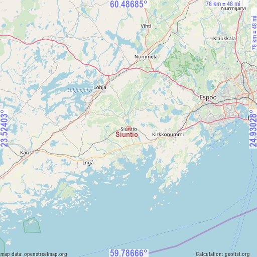
Siuntio GPS coordinates[2]
60° 8' 19.032" North, 24° 13' 37.74" East
| Map corner | latitude | longitude |
|---|---|---|
| Upper-left | 60.48685°, | 23.52403° |
| Center: | 60.13862°, | 24.22715° |
| Lower-right: | 59.78666°, | 24.93028° |
| Map W x H: | 77.9×77.9 km | = 48.4×48.4mi |
| max Lat: | 69.90864° ⇑98.1% North |
| Siuntio: | 60.13862° |
| min Lat: | ⇓1.9% South 59.83333° |
| min Long | Siuntio | max Long |
| 21.2° | 24.22715° | 30.93276° |
| W 41.9%⇐ | ⇒58.1% E |
Elevation
Elevation of Siuntio is 40 m = 131 ft, and this is 37.1 m = 122 ft below average elevation for this country.
| Max E: |
299 m = 981 ft | 69.9% |
| Avg. | 77.1 m = 253 ft | |
| Siuntio | 40 m = 131 ft | |
Min E: |
1 m = 3 ft | 30.1% |
See also: Finland elevation on elevation.city.
Geographical zone
Siuntio is located in North temperate zone (between Tropic of Cancer and the Arctic Circle). Distance of this North polar circle is 714.4 km =443.9 mi to North.| Distance of | km | miles | from Siuntio |
|---|---|---|---|
| North Pole | 3320.3 | 2063.1 | to North |
| Arctic Circle | 714.4 | 443.9 | to North |
| Tropic Cancer | 4080.9 | 2535.8 | to South |
| Equator | 6686.8 | 4155 | to South |


Nearby cities:
15 places around Siuntio: (largest is in red/bold)
• Espoo
24.6 km =15.3 mi,  72°
72°
• Gumböle
23.3 km =14.5 mi, 67°
• Ingå
16.1 km =10 mi,  230°
230°
• Karis
32.2 km =20 mi,  256°
256°
• Karjalohja
30.3 km =18.8 mi,  291°
291°
• Kauniainen
28.9 km =18 mi, 73°
• Kilo
31.9 km =19.8 mi, 74°
• Kirkkonummi
11.8 km =7.3 mi,  98°
98°
• Koukkuniemi
29.8 km =18.5 mi,  87°
87°
• Lauttasaari
35.5 km =22.1 mi, 86°
• Lohja
15.1 km =9.4 mi,  323°
323°
• Otaniemi
33.6 km =20.9 mi,  81°
81°
• Sammatti
30.2 km =18.8 mi,  311°
311°
• Saukkola
30.4 km =18.9 mi,  333°
333°
• Vihti
31.4 km =19.5 mi,  9°
9°
Sources, notices
• [Note1] Compared only with cities in Finland existing in our database
• [Src1] Map data: © OpenStreetMap contributors (CC-BY-SA)
• [Src2] Other city data from geonames.org with taken over terms of usage.
• [Src3] Geographical zone / Annual Mean Temperature by Robert A. Rohde @ Wikipedia
