Karjalohja geodata
Karjalohja (Uusimaa) is a populated place; located in Finland in Europe/Helsinki (GMT+3) time zone. With population of 1,657 people, there are 380 cities with bigger population in this country. Compared to other cities in Finland, 93.8% of cities are located further ↑North; 65.4% of cities are located further →East and 67.1% of cities have higher elevation than Karjalohja. Note1


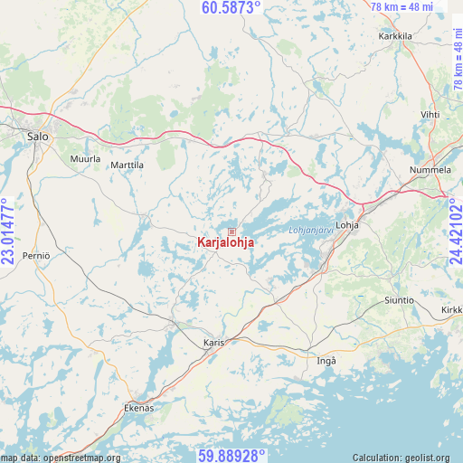
Karjalohja GPS coordinates[2]
60° 14' 24.54" North, 23° 43' 4.404" East
| Map corner | latitude | longitude |
|---|---|---|
| Upper-left | 60.5873°, | 23.01477° |
| Center: | 60.24015°, | 23.71789° |
| Lower-right: | 59.88928°, | 24.42102° |
| Map W x H: | 77.6×77.6 km | = 48.2×48.2mi |
| max Lat: | 69.90864° ⇑93.8% North |
| Karjalohja: | 60.24015° |
| min Lat: | ⇓6.2% South 59.83333° |
| min Long | Karjalohja | max Long |
| 21.2° | 23.71789° | 30.93276° |
| W 34.6%⇐ | ⇒65.4% E |
Elevation
Elevation of Karjalohja is 48 m = 157 ft, and this is 29.1 m = 95 ft below average elevation for this country.
| Max E: |
299 m = 981 ft | 67.1% |
| Avg. | 77.1 m = 253 ft | |
| Karjalohja | 48 m = 157 ft | |
Min E: |
1 m = 3 ft | 32.9% |
See also: Finland elevation on elevation.city.
Geographical zone
Karjalohja is located in North temperate zone (between Tropic of Cancer and the Arctic Circle). Distance of this North polar circle is 703.1 km =436.9 mi to North.| Distance of | km | miles | from Karjalohja |
|---|---|---|---|
| North Pole | 3309 | 2056.1 | to North |
| Arctic Circle | 703.1 | 436.9 | to North |
| Tropic Cancer | 4092.2 | 2542.8 | to South |
| Equator | 6698.1 | 4162 | to South |


Nearby cities:
15 places around Karjalohja: (largest is in red/bold)
• Ekenäs
33.6 km =20.9 mi,  207°
207°
• Ingå
26.8 km =16.7 mi,  143°
143°
• Karis
19 km =11.8 mi,  189°
189°
• Kiikala
26.5 km =16.5 mi,  341°
341°
• Kisko
13 km =8.1 mi,  266°
266°
• Lohja
19.2 km =11.9 mi,  87°
87°
• Muurla
26.9 km =16.7 mi,  297°
297°
• Perniö
32.6 km =20.3 mi,  262°
262°
• Pertteli
32.8 km =20.4 mi,  310°
310°
• Pohja
19.2 km =11.9 mi, 213°
• Salo
35.9 km =22.3 mi, 296°
• Sammatti
10.5 km =6.5 mi,  32°
32°
• Saukkola
21.6 km =13.4 mi,  42°
42°
• Siuntio
30.3 km =18.8 mi,  111°
111°
• Suomusjärvi
12.8 km =8 mi, 342°
Sources, notices
• [Note1] Compared only with cities in Finland existing in our database
• [Src1] Map data: © OpenStreetMap contributors (CC-BY-SA)
• [Src2] Other city data from geonames.org with taken over terms of usage.
• [Src3] Geographical zone / Annual Mean Temperature by Robert A. Rohde @ Wikipedia
