Ranua geodata
Ranua (Lapland) is a seat of a third-order administrative division; located in Finland in Europe/Helsinki (GMT+3) time zone. With population of 4,833 people, there are 215 cities with bigger population in this country. Compared to other cities in Finland, 95.7% of cities are located further ↓South; 75.9% of cities are located further ←West and 93.8% of cities have lower elevation than Ranua. Note1


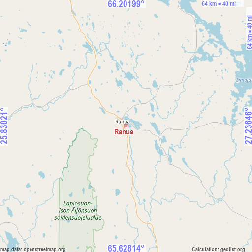
Ranua GPS coordinates[2]
65° 55' 0.012" North, 26° 31' 59.988" East
| Map corner | latitude | longitude |
|---|---|---|
| Upper-left | 66.20199°, | 25.83021° |
| Center: | 65.91667°, | 26.53333° |
| Lower-right: | 65.62814°, | 27.23646° |
| Map W x H: | 63.8×63.8 km | = 39.6×39.6mi |
| max Lat: | 69.90864° ⇑4.3% North |
| Ranua: | 65.91667° |
| min Lat: | ⇓95.7% South 59.83333° |
| min Long | Ranua | max Long |
| 21.2° | 26.53333° | 30.93276° |
| W 75.9%⇐ | ⇒24.1% E |
Elevation
Elevation of Ranua is 152 m = 499 ft, and this is 74.9 m = 246 ft above average elevation for this country.
| Max E: |
299 m = 981 ft | 6.2% |
| Ranua | 152 m 499 ft | |
| Avg. | 77.1 m = 253 ft | |
Min E: |
1 m = 3 ft | 93.8% |
See also: Finland elevation on elevation.city.
Geographical zone
Ranua is located in North temperate zone (between Tropic of Cancer and the Arctic Circle). Distance of this North polar circle is 71.9 km =44.7 mi to North.| Distance of | km | miles | from Ranua |
|---|---|---|---|
| North Pole | 2677.8 | 1663.9 | to North |
| Arctic Circle | 71.9 | 44.7 | to North |
| Tropic Cancer | 4723.3 | 2934.9 | to South |
| Equator | 7329.2 | 4554.2 | to South |


Nearby cities:
15 places around Ranua: (largest is in red/bold)
• Haukipudas
98.6 km =61.3 mi,  213°
213°
• Ii
85.3 km =53 mi,  218°
218°
• Kemi
91.9 km =57.1 mi,  257°
257°
• Kemijärvi
97.2 km =60.4 mi,  24°
24°
• Keminmaa
91.3 km =56.7 mi, 261°
• Kiiminki
93.7 km =58.2 mi,  201°
201°
• Kuivaniemi
72 km =44.7 mi,  238°
238°
• Posio
77.1 km =47.9 mi,  73°
73°
• Pudasjärvi
61.9 km =38.5 mi,  163°
163°
• Rovaniemi
74.5 km =46.3 mi,  330°
330°
• Simo
73.1 km =45.4 mi,  247°
247°
• Taivalkoski
87.5 km =54.4 mi,  116°
116°
• Tervola
80.5 km =50 mi,  283°
283°
• Yli-Ii
68.3 km =42.4 mi, 207°
• Ylikiiminki
93.6 km =58.2 mi,  188°
188°
Sources, notices
• [Note1] Compared only with cities in Finland existing in our database
• [Src1] Map data: © OpenStreetMap contributors (CC-BY-SA)
• [Src2] Other city data from geonames.org with taken over terms of usage.
• [Src3] Geographical zone / Annual Mean Temperature by Robert A. Rohde @ Wikipedia
