Nokia geodata
Nokia (Pirkanmaa) is a seat of a third-order administrative division; located in Finland in Europe/Helsinki (GMT+3) time zone. With population of 28,676 people, there are 33 cities with bigger population in this country. Compared to other cities in Finland, 57.5% of cities are located further ↑North; 69.9% of cities are located further →East and 56% of cities have lower elevation than Nokia. Note1


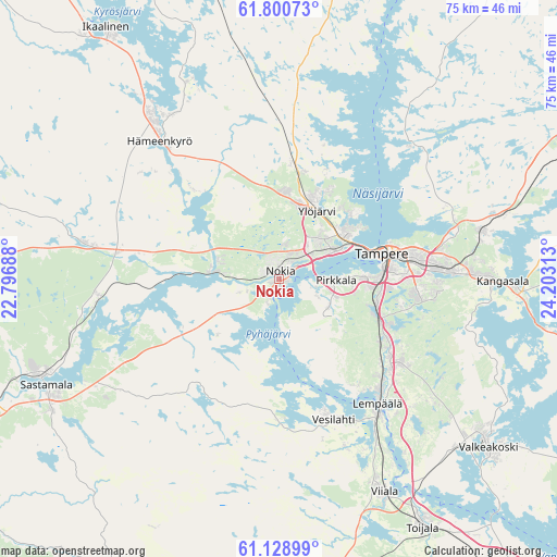
Nokia GPS coordinates[2]
61° 28' 0.012" North, 23° 30' 0" East
| Map corner | latitude | longitude |
|---|---|---|
| Upper-left | 61.80073°, | 22.79688° |
| Center: | 61.46667°, | 23.5° |
| Lower-right: | 61.12899°, | 24.20313° |
| Map W x H: | 74.7×74.7 km | = 46.4×46.4mi |
| max Lat: | 69.90864° ⇑57.5% North |
| Nokia: | 61.46667° |
| min Lat: | ⇓42.5% South 59.83333° |
| min Long | Nokia | max Long |
| 21.2° | 23.5° | 30.93276° |
| W 30.1%⇐ | ⇒69.9% E |
Elevation
Elevation of Nokia is 89 m = 292 ft, and this is 11.9 m = 39 ft above average elevation for this country.
| Max E: |
299 m = 981 ft | 44% |
| Nokia | 89 m 292 ft | |
| Avg. | 77.1 m = 253 ft | |
Min E: |
1 m = 3 ft | 56% |
See also: Finland elevation on elevation.city.
Geographical zone
Nokia is located in North temperate zone (between Tropic of Cancer and the Arctic Circle). Distance of this North polar circle is 566.7 km =352.1 mi to North.| Distance of | km | miles | from Nokia |
|---|---|---|---|
| North Pole | 3172.6 | 1971.4 | to North |
| Arctic Circle | 566.7 | 352.1 | to North |
| Tropic Cancer | 4228.5 | 2627.5 | to South |
| Equator | 6834.5 | 4246.8 | to South |


Nearby cities:
15 places around Nokia: (largest is in red/bold)
• Akaa
38.7 km =24 mi,  149°
149°
• Hämeenkyrö
25.1 km =15.6 mi,  319°
319°
• Kangasala
30.6 km =19 mi,  90°
90°
• Kylmäkoski
36.2 km =22.5 mi,  163°
163°
• Lempäälä
21.3 km =13.2 mi,  141°
141°
• Mouhijärvi
25.9 km =16.1 mi,  278°
278°
• Pirkkala
7.1 km =4.4 mi, 94°
• Tampere
15.7 km =9.8 mi,  76°
76°
• Toijala
37.8 km =23.5 mi, 151°
• Valkeakoski
36.2 km =22.5 mi,  128°
128°
• Vammala
35.2 km =21.9 mi,  245°
245°
• Vesilahti
17.8 km =11.1 mi, 159°
• Viiala
31.9 km =19.8 mi, 153°
• Viljakkala
29.3 km =18.2 mi,  335°
335°
• Ylöjärvi
11.2 km =7 mi,  27°
27°
Sources, notices
• [Note1] Compared only with cities in Finland existing in our database
• [Src1] Map data: © OpenStreetMap contributors (CC-BY-SA)
• [Src2] Other city data from geonames.org with taken over terms of usage.
• [Src3] Geographical zone / Annual Mean Temperature by Robert A. Rohde @ Wikipedia
