Valkeakoski geodata
Valkeakoski (Pirkanmaa) is a seat of a third-order administrative division; located in Finland in Europe/Helsinki (GMT+3) time zone. With population of 20,376 people, there are 53 cities with bigger population in this country. Compared to other cities in Finland, 62% of cities are located further ↑North; 60.5% of cities are located further →East and 62.8% of cities have lower elevation than Valkeakoski. Note1


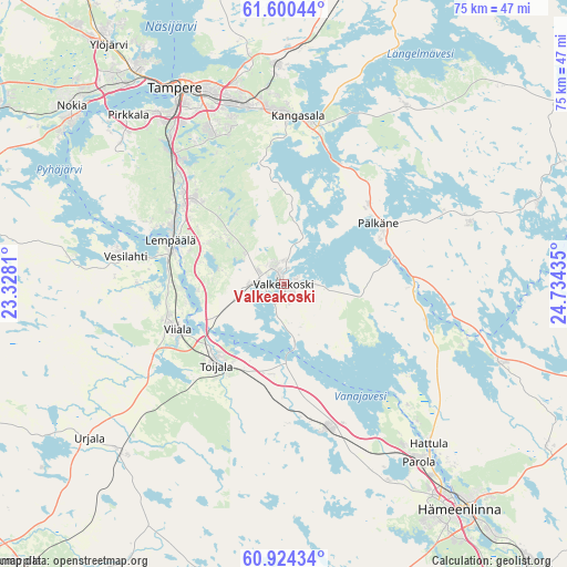
Valkeakoski GPS coordinates[2]
61° 15' 51.156" North, 24° 1' 52.392" East
| Map corner | latitude | longitude |
|---|---|---|
| Upper-left | 61.60044°, | 23.3281° |
| Center: | 61.26421°, | 24.03122° |
| Lower-right: | 60.92434°, | 24.73435° |
| Map W x H: | 75.2×75.2 km | = 46.7×46.7mi |
| max Lat: | 69.90864° ⇑62% North |
| Valkeakoski: | 61.26421° |
| min Lat: | ⇓38% South 59.83333° |
| min Long | Valkeakoski | max Long |
| 21.2° | 24.03122° | 30.93276° |
| W 39.5%⇐ | ⇒60.5% E |
Elevation
Elevation of Valkeakoski is 98 m = 322 ft, and this is 20.9 m = 69 ft above average elevation for this country.
| Max E: |
299 m = 981 ft | 37.2% |
| Valkeakoski | 98 m 322 ft | |
| Avg. | 77.1 m = 253 ft | |
Min E: |
1 m = 3 ft | 62.8% |
See also: Finland elevation on elevation.city.
Geographical zone
Valkeakoski is located in North temperate zone (between Tropic of Cancer and the Arctic Circle). Distance of this North polar circle is 589.2 km =366.1 mi to North.| Distance of | km | miles | from Valkeakoski |
|---|---|---|---|
| North Pole | 3195.1 | 1985.3 | to North |
| Arctic Circle | 589.2 | 366.1 | to North |
| Tropic Cancer | 4206 | 2613.5 | to South |
| Equator | 6811.9 | 4232.7 | to South |


Nearby cities:
15 places around Valkeakoski: (largest is in red/bold)
• Akaa
14 km =8.7 mi,  219°
219°
• Hauho
30.2 km =18.8 mi,  109°
109°
• Kalvola
18.8 km =11.7 mi,  165°
165°
• Kangasala
22.3 km =13.9 mi,  6°
6°
• Kylmäkoski
22.1 km =13.7 mi,  236°
236°
• Lempäälä
16.1 km =10 mi,  291°
291°
• Parola
29.8 km =18.5 mi,  144°
144°
• Pirkkala
30.5 km =19 mi,  315°
315°
• Pälkäne
15 km =9.3 mi,  58°
58°
• Sahalahti
28.2 km =17.5 mi,  33°
33°
• Tampere
29.2 km =18.1 mi,  333°
333°
• Toijala
14.9 km =9.3 mi, 223°
• Urjala
33.4 km =20.8 mi,  233°
233°
• Vesilahti
22.9 km =14.2 mi,  284°
284°
• Viiala
15.3 km =9.5 mi,  246°
246°
Sources, notices
• [Note1] Compared only with cities in Finland existing in our database
• [Src1] Map data: © OpenStreetMap contributors (CC-BY-SA)
• [Src2] Other city data from geonames.org with taken over terms of usage.
• [Src3] Geographical zone / Annual Mean Temperature by Robert A. Rohde @ Wikipedia
