Viiala geodata
Viiala (Pirkanmaa) is a populated place; located in Finland in Europe/Helsinki (GMT+3) time zone. With population of 5,472 people, there are 194 cities with bigger population in this country. Compared to other cities in Finland, 62.8% of cities are located further ↑North; 64.7% of cities are located further →East and 51.9% of cities have higher elevation than Viiala. Note1


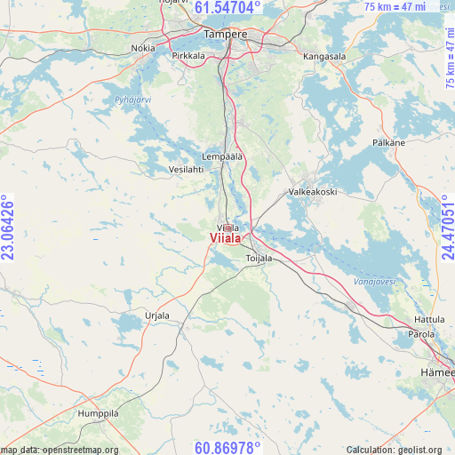
Viiala GPS coordinates[2]
61° 12' 36.828" North, 23° 46' 2.568" East
| Map corner | latitude | longitude |
|---|---|---|
| Upper-left | 61.54704°, | 23.06426° |
| Center: | 61.21023°, | 23.76738° |
| Lower-right: | 60.86978°, | 24.47051° |
| Map W x H: | 75.3×75.3 km | = 46.8×46.8mi |
| max Lat: | 69.90864° ⇑62.8% North |
| Viiala: | 61.21023° |
| min Lat: | ⇓37.2% South 59.83333° |
| min Long | Viiala | max Long |
| 21.2° | 23.76738° | 30.93276° |
| W 35.3%⇐ | ⇒64.7% E |
Elevation
Elevation of Viiala is 78 m = 256 ft, and this is 0.90000000000001 m = 3 ft above average elevation for this country.
| Max E: |
299 m = 981 ft | 51.9% |
| Viiala | 78 m 256 ft | |
| Avg. | 77.1 m = 253 ft | |
Min E: |
1 m = 3 ft | 48.1% |
See also: Finland elevation on elevation.city.
Geographical zone
Viiala is located in North temperate zone (between Tropic of Cancer and the Arctic Circle). Distance of this North polar circle is 595.2 km =369.8 mi to North.| Distance of | km | miles | from Viiala |
|---|---|---|---|
| North Pole | 3201.1 | 1989.1 | to North |
| Arctic Circle | 595.2 | 369.8 | to North |
| Tropic Cancer | 4200 | 2609.8 | to South |
| Equator | 6805.9 | 4229 | to South |


Nearby cities:
15 places around Viiala: (largest is in red/bold)
• Akaa
7.2 km =4.5 mi,  132°
132°
• Kalvola
22.6 km =14 mi,  122°
122°
• Kangasala
32.7 km =20.3 mi,  30°
30°
• Kylmäkoski
7.5 km =4.7 mi,  214°
214°
• Lempäälä
11.9 km =7.4 mi,  355°
355°
• Nokia
31.9 km =19.8 mi,  333°
333°
• Parola
36.4 km =22.6 mi, 120°
• Pirkkala
28.8 km =17.9 mi,  345°
345°
• Punkalaidun
37.3 km =23.2 mi,  253°
253°
• Pälkäne
30.3 km =18.8 mi,  62°
62°
• Tampere
32.1 km =19.9 mi,  1°
1°
• Toijala
6.1 km =3.8 mi,  141°
141°
• Urjala
18.9 km =11.7 mi,  221°
221°
• Valkeakoski
15.3 km =9.5 mi,  66°
66°
• Vesilahti
14.3 km =8.9 mi, 325°
Sources, notices
• [Note1] Compared only with cities in Finland existing in our database
• [Src1] Map data: © OpenStreetMap contributors (CC-BY-SA)
• [Src2] Other city data from geonames.org with taken over terms of usage.
• [Src3] Geographical zone / Annual Mean Temperature by Robert A. Rohde @ Wikipedia
