Mellunkylä geodata
Mellunkylä (Uusimaa) is a section of populated place; located in Finland in Europe/Helsinki (GMT+3) time zone. With population of 36,360 people, there are 21 cities with bigger population in this country. Compared to other cities in Finland, 94% of cities are located further ↑North; 57.1% of cities are located further ←West and 79.9% of cities have higher elevation than Mellunkylä. Note1


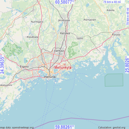
Mellunkylä GPS coordinates[2]
60° 14' 0.78" North, 25° 5' 58.092" East
| Map corner | latitude | longitude |
|---|---|---|
| Upper-left | 60.58077°, | 24.39635° |
| Center: | 60.23355°, | 25.09947° |
| Lower-right: | 59.88261°, | 25.8026° |
| Map W x H: | 77.6×77.6 km | = 48.2×48.2mi |
| max Lat: | 69.90864° ⇑94% North |
| Mellunkylä: | 60.23355° |
| min Lat: | ⇓6% South 59.83333° |
| min Long | Mellunkylä | max Long |
| 21.2° | 25.09947° | 30.93276° |
| W 57.1%⇐ | ⇒42.9% E |
Elevation
Elevation of Mellunkylä is 19 m = 62 ft, and this is 58.1 m = 191 ft below average elevation for this country.
| Max E: |
299 m = 981 ft | 79.9% |
| Avg. | 77.1 m = 253 ft | |
| Mellunkylä | 19 m = 62 ft | |
Min E: |
1 m = 3 ft | 20.1% |
See also: Finland elevation on elevation.city.
Geographical zone
Mellunkylä is located in North temperate zone (between Tropic of Cancer and the Arctic Circle). Distance of this North polar circle is 703.8 km =437.3 mi to North.| Distance of | km | miles | from Mellunkylä |
|---|---|---|---|
| North Pole | 3309.7 | 2056.6 | to North |
| Arctic Circle | 703.8 | 437.3 | to North |
| Tropic Cancer | 4091.4 | 2542.3 | to South |
| Equator | 6697.3 | 4161.5 | to South |


Nearby cities:
15 places around Mellunkylä: (largest is in red/bold)
• Helsinki
11.5 km =7.1 mi,  231°
231°
• Kaarela
12.2 km =7.6 mi,  279°
279°
• Kallio
9.9 km =6.2 mi,  236°
236°
• Kerava
18.9 km =11.7 mi,  0°
0°
• Kilo
17.6 km =10.9 mi,  264°
264°
• Lauttasaari
15.2 km =9.4 mi, 237°
• Munkkiniemi
12.8 km =8 mi,  252°
252°
• Nickby
19.5 km =12.1 mi,  31°
31°
• Otaniemi
16 km =9.9 mi, 249°
• Sibbo
18.5 km =11.5 mi, 30°
• Suomenlinna
11.4 km =7.1 mi,  213°
213°
• Tuusula
19.3 km =12 mi,  347°
347°
• Vantaa
7.5 km =4.7 mi,  334°
334°
• Vuosaari
3.5 km =2.2 mi,  138°
138°
• Östersundom
5.8 km =3.6 mi,  62°
62°
Sources, notices
• [Note1] Compared only with cities in Finland existing in our database
• [Src1] Map data: © OpenStreetMap contributors (CC-BY-SA)
• [Src2] Other city data from geonames.org with taken over terms of usage.
• [Src3] Geographical zone / Annual Mean Temperature by Robert A. Rohde @ Wikipedia
