Kerava geodata
Kerava (Uusimaa) is a seat of a third-order administrative division; located in Finland in Europe/Helsinki (GMT+3) time zone. With population of 31,347 people, there are 30 cities with bigger population in this country. Compared to other cities in Finland, 89.7% of cities are located further ↑North; 57.5% of cities are located further ←West and 62.8% of cities have higher elevation than Kerava. Note1


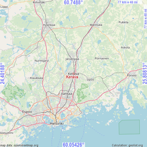
Kerava GPS coordinates[2]
60° 24' 12.168" North, 25° 6' 18" East
| Map corner | latitude | longitude |
|---|---|---|
| Upper-left | 60.7488°, | 24.40188° |
| Center: | 60.40338°, | 25.105° |
| Lower-right: | 60.05426°, | 25.80813° |
| Map W x H: | 77.2×77.2 km | = 48×48mi |
| max Lat: | 69.90864° ⇑89.7% North |
| Kerava: | 60.40338° |
| min Lat: | ⇓10.3% South 59.83333° |
| min Long | Kerava | max Long |
| 21.2° | 25.105° | 30.93276° |
| W 57.5%⇐ | ⇒42.5% E |
Elevation
Elevation of Kerava is 54 m = 177 ft, and this is 23.1 m = 76 ft below average elevation for this country.
| Max E: |
299 m = 981 ft | 62.8% |
| Avg. | 77.1 m = 253 ft | |
| Kerava | 54 m = 177 ft | |
Min E: |
1 m = 3 ft | 37.2% |
See also: Finland elevation on elevation.city.
Geographical zone
Kerava is located in North temperate zone (between Tropic of Cancer and the Arctic Circle). Distance of this North polar circle is 684.9 km =425.6 mi to North.| Distance of | km | miles | from Kerava |
|---|---|---|---|
| North Pole | 3290.8 | 2044.8 | to North |
| Arctic Circle | 684.9 | 425.6 | to North |
| Tropic Cancer | 4110.3 | 2554 | to South |
| Equator | 6716.2 | 4173.3 | to South |


Nearby cities:
15 places around Kerava: (largest is in red/bold)
• Järvenpää
7.9 km =4.9 mi,  353°
353°
• Kaarela
20.9 km =13 mi,  216°
216°
• Kallio
25.8 km =16 mi,  199°
199°
• Kellokoski
14.4 km =8.9 mi,  0°
0°
• Kilo
27.3 km =17 mi, 220°
• Mellunkylä
18.9 km =11.7 mi,  180°
180°
• Munkkiniemi
26 km =16.2 mi,  208°
208°
• Nickby
10 km =6.2 mi,  102°
102°
• Nurmijärvi
17.7 km =11 mi,  292°
292°
• Pornainen
16.9 km =10.5 mi,  61°
61°
• Sibbo
9.5 km =5.9 mi,  107°
107°
• Tuusula
4.3 km =2.7 mi,  270°
270°
• Vantaa
12.6 km =7.8 mi, 196°
• Vuosaari
21.6 km =13.4 mi,  174°
174°
• Östersundom
16.9 km =10.5 mi,  163°
163°
Sources, notices
• [Note1] Compared only with cities in Finland existing in our database
• [Src1] Map data: © OpenStreetMap contributors (CC-BY-SA)
• [Src2] Other city data from geonames.org with taken over terms of usage.
• [Src3] Geographical zone / Annual Mean Temperature by Robert A. Rohde @ Wikipedia
