Marttila geodata
Marttila (Southwest Finland) is a seat of a third-order administrative division; located in Finland in Europe/Helsinki (GMT+3) time zone. With population of 2,125 people, there are 345 cities with bigger population in this country. Compared to other cities in Finland, 81.4% of cities are located further ↑North; 76.9% of cities are located further →East and 57.3% of cities have higher elevation than Marttila. Note1


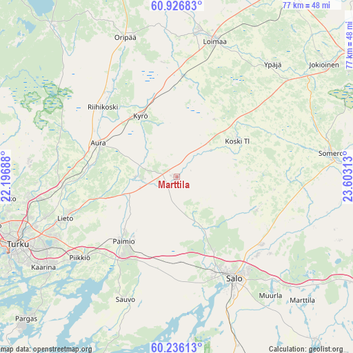
Marttila GPS coordinates[2]
60° 34' 59.988" North, 22° 54' 0" East
| Map corner | latitude | longitude |
|---|---|---|
| Upper-left | 60.92683°, | 22.19688° |
| Center: | 60.58333°, | 22.9° |
| Lower-right: | 60.23613°, | 23.60313° |
| Map W x H: | 76.8×76.8 km | = 47.7×47.7mi |
| max Lat: | 69.90864° ⇑81.4% North |
| Marttila: | 60.58333° |
| min Lat: | ⇓18.6% South 59.83333° |
| min Long | Marttila | max Long |
| 21.2° | 22.9° | 30.93276° |
| W 23.1%⇐ | ⇒76.9% E |
Elevation
Elevation of Marttila is 68 m = 223 ft, and this is 9.1 m = 30 ft below average elevation for this country.
| Max E: |
299 m = 981 ft | 57.3% |
| Avg. | 77.1 m = 253 ft | |
| Marttila | 68 m = 223 ft | |
Min E: |
1 m = 3 ft | 42.7% |
See also: Finland elevation on elevation.city.
Geographical zone
Marttila is located in North temperate zone (between Tropic of Cancer and the Arctic Circle). Distance of this North polar circle is 664.9 km =413.1 mi to North.| Distance of | km | miles | from Marttila |
|---|---|---|---|
| North Pole | 3270.8 | 2032.4 | to North |
| Arctic Circle | 664.9 | 413.1 | to North |
| Tropic Cancer | 4130.3 | 2566.4 | to South |
| Equator | 6736.2 | 4185.7 | to South |


Nearby cities:
15 places around Marttila: (largest is in red/bold)
• Aura
18.5 km =11.5 mi,  292°
292°
• Halikko
22.7 km =14.1 mi,  153°
153°
• Karinainen
11.8 km =7.3 mi,  321°
321°
• Koski Tl
15.5 km =9.6 mi,  61°
61°
• Kuusjoki
18 km =11.2 mi,  114°
114°
• Kyrö
15.3 km =9.5 mi,  327°
327°
• Lieto
25.3 km =15.7 mi,  251°
251°
• Mellilä
20.6 km =12.8 mi,  7°
7°
• Paimio
18.3 km =11.4 mi,  219°
219°
• Pertteli
26.1 km =16.2 mi,  129°
129°
• Piikkiö
27.4 km =17 mi,  230°
230°
• Pöytyä
24 km =14.9 mi, 328°
• Salo
25.6 km =15.9 mi, 150°
• Sauvo
29 km =18 mi,  202°
202°
• Tarvasjoki
9.1 km =5.7 mi,  270°
270°
Sources, notices
• [Note1] Compared only with cities in Finland existing in our database
• [Src1] Map data: © OpenStreetMap contributors (CC-BY-SA)
• [Src2] Other city data from geonames.org with taken over terms of usage.
• [Src3] Geographical zone / Annual Mean Temperature by Robert A. Rohde @ Wikipedia
