Tarvasjoki geodata
Tarvasjoki (Southwest Finland) is a populated place; located in Finland in Europe/Helsinki (GMT+3) time zone. With population of 1,961 people, there are 360 cities with bigger population in this country. Compared to other cities in Finland, 81.4% of cities are located further ↑North; 79.3% of cities are located further →East and 66.5% of cities have higher elevation than Tarvasjoki. Note1


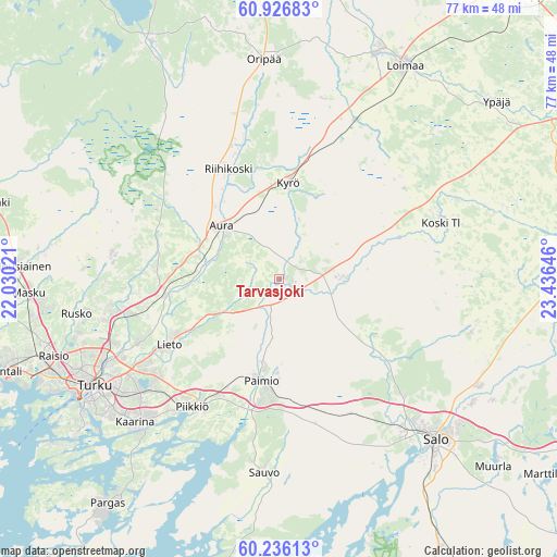
Tarvasjoki GPS coordinates[2]
60° 34' 59.988" North, 22° 43' 59.988" East
| Map corner | latitude | longitude |
|---|---|---|
| Upper-left | 60.92683°, | 22.03021° |
| Center: | 60.58333°, | 22.73333° |
| Lower-right: | 60.23613°, | 23.43646° |
| Map W x H: | 76.8×76.8 km | = 47.7×47.7mi |
| max Lat: | 69.90864° ⇑81.4% North |
| Tarvasjoki: | 60.58333° |
| min Lat: | ⇓18.6% South 59.83333° |
| min Long | Tarvasjoki | max Long |
| 21.2° | 22.73333° | 30.93276° |
| W 20.7%⇐ | ⇒79.3% E |
Elevation
Elevation of Tarvasjoki is 49 m = 161 ft, and this is 28.1 m = 92 ft below average elevation for this country.
| Max E: |
299 m = 981 ft | 66.5% |
| Avg. | 77.1 m = 253 ft | |
| Tarvasjoki | 49 m = 161 ft | |
Min E: |
1 m = 3 ft | 33.5% |
See also: Finland elevation on elevation.city.
Geographical zone
Tarvasjoki is located in North temperate zone (between Tropic of Cancer and the Arctic Circle). Distance of this North polar circle is 664.9 km =413.1 mi to North.| Distance of | km | miles | from Tarvasjoki |
|---|---|---|---|
| North Pole | 3270.8 | 2032.4 | to North |
| Arctic Circle | 664.9 | 413.1 | to North |
| Tropic Cancer | 4130.3 | 2566.4 | to South |
| Equator | 6736.2 | 4185.7 | to South |


Nearby cities:
15 places around Tarvasjoki: (largest is in red/bold)
• Aura
10.7 km =6.6 mi,  311°
311°
• Halikko
28 km =17.4 mi,  136°
136°
• Kaarina
28 km =17.4 mi,  225°
225°
• Karinainen
9.4 km =5.8 mi,  11°
11°
• Koski Tl
23.9 km =14.9 mi,  71°
71°
• Kuusjoki
26.6 km =16.5 mi,  106°
106°
• Kyrö
13 km =8.1 mi,  4°
4°
• Lieto
16.9 km =10.5 mi,  241°
241°
• Marttila
9.1 km =5.7 mi,  90°
90°
• Mellilä
23.6 km =14.7 mi,  30°
30°
• Paimio
14.3 km =8.9 mi,  190°
190°
• Piikkiö
21.3 km =13.2 mi,  214°
214°
• Pöytyä
20.7 km =12.9 mi,  349°
349°
• Sauvo
26.8 km =16.7 mi,  184°
184°
• Vahto
23.7 km =14.7 mi,  274°
274°
Sources, notices
• [Note1] Compared only with cities in Finland existing in our database
• [Src1] Map data: © OpenStreetMap contributors (CC-BY-SA)
• [Src2] Other city data from geonames.org with taken over terms of usage.
• [Src3] Geographical zone / Annual Mean Temperature by Robert A. Rohde @ Wikipedia
