Mellilä geodata
Mellilä (Southwest Finland) is a seat of a third-order administrative division; located in Finland in Europe/Helsinki (GMT+3) time zone. With population of 1,141 people, there are 420 cities with bigger population in this country. Compared to other cities in Finland, 76.1% of cities are located further ↑North; 76.3% of cities are located further →East and 51.9% of cities have higher elevation than Mellilä. Note1


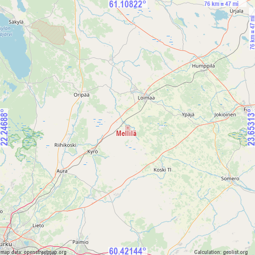
Mellilä GPS coordinates[2]
60° 46' 0.012" North, 22° 57' 0" East
| Map corner | latitude | longitude |
|---|---|---|
| Upper-left | 61.10822°, | 22.24688° |
| Center: | 60.76667°, | 22.95° |
| Lower-right: | 60.42144°, | 23.65313° |
| Map W x H: | 76.4×76.4 km | = 47.5×47.5mi |
| max Lat: | 69.90864° ⇑76.1% North |
| Mellilä: | 60.76667° |
| min Lat: | ⇓23.9% South 59.83333° |
| min Long | Mellilä | max Long |
| 21.2° | 22.95° | 30.93276° |
| W 23.7%⇐ | ⇒76.3% E |
Elevation
Elevation of Mellilä is 78 m = 256 ft, and this is 0.90000000000001 m = 3 ft above average elevation for this country.
| Max E: |
299 m = 981 ft | 51.9% |
| Mellilä | 78 m 256 ft | |
| Avg. | 77.1 m = 253 ft | |
Min E: |
1 m = 3 ft | 48.1% |
See also: Finland elevation on elevation.city.
Geographical zone
Mellilä is located in North temperate zone (between Tropic of Cancer and the Arctic Circle). Distance of this North polar circle is 644.6 km =400.5 mi to North.| Distance of | km | miles | from Mellilä |
|---|---|---|---|
| North Pole | 3250.4 | 2019.7 | to North |
| Arctic Circle | 644.6 | 400.5 | to North |
| Tropic Cancer | 4150.7 | 2579.1 | to South |
| Equator | 6756.6 | 4198.4 | to South |


Nearby cities:
15 places around Mellilä: (largest is in red/bold)
• Alastaro
21.1 km =13.1 mi,  345°
345°
• Aura
23.8 km =14.8 mi,  236°
236°
• Humppila
29.2 km =18.1 mi,  50°
50°
• Jokioinen
29 km =18 mi,  82°
82°
• Karinainen
14.9 km =9.3 mi,  221°
221°
• Koski Tl
16.9 km =10.5 mi,  140°
140°
• Kuusjoki
31 km =19.3 mi,  153°
153°
• Kyrö
13.2 km =8.2 mi, 235°
• Loimaa
10.9 km =6.8 mi,  31°
31°
• Marttila
20.6 km =12.8 mi,  187°
187°
• Oripää
17.2 km =10.7 mi,  302°
302°
• Pöytyä
15.4 km =9.6 mi,  270°
270°
• Tarvasjoki
23.6 km =14.7 mi,  210°
210°
• Vampula
30.9 km =19.2 mi,  334°
334°
• Ypäjä
18.5 km =11.5 mi, 78°
Sources, notices
• [Note1] Compared only with cities in Finland existing in our database
• [Src1] Map data: © OpenStreetMap contributors (CC-BY-SA)
• [Src2] Other city data from geonames.org with taken over terms of usage.
• [Src3] Geographical zone / Annual Mean Temperature by Robert A. Rohde @ Wikipedia
