Laitila geodata
Laitila (Southwest Finland) is a seat of a third-order administrative division; located in Finland in Europe/Helsinki (GMT+3) time zone. With population of 8,403 people, there are 131 cities with bigger population in this country. Compared to other cities in Finland, 72.6% of cities are located further ↑North; 95.3% of cities are located further →East and 81.4% of cities have higher elevation than Laitila. Note1


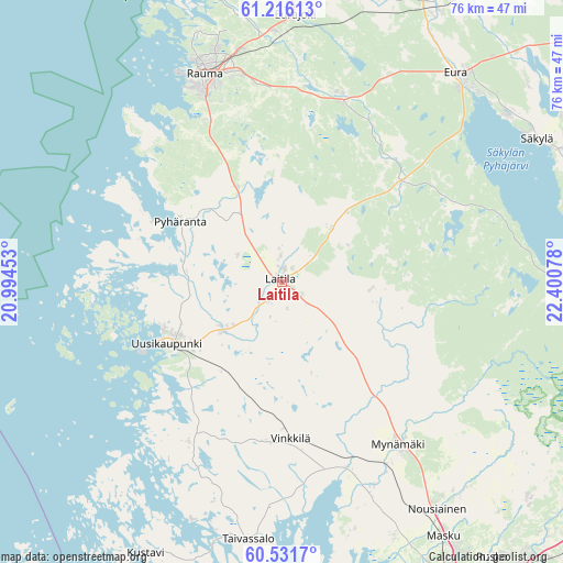
Laitila GPS coordinates[2]
60° 52' 32.7" North, 21° 41' 51.54" East
| Map corner | latitude | longitude |
|---|---|---|
| Upper-left | 61.21613°, | 20.99453° |
| Center: | 60.87575°, | 21.69765° |
| Lower-right: | 60.5317°, | 22.40078° |
| Map W x H: | 76.1×76.1 km | = 47.3×47.3mi |
| max Lat: | 69.90864° ⇑72.6% North |
| Laitila: | 60.87575° |
| min Lat: | ⇓27.4% South 59.83333° |
| min Long | Laitila | max Long |
| 21.2° | 21.69765° | 30.93276° |
| W 4.7%⇐ | ⇒95.3% E |
Elevation
Elevation of Laitila is 18 m = 59 ft, and this is 59.1 m = 194 ft below average elevation for this country.
| Max E: |
299 m = 981 ft | 81.4% |
| Avg. | 77.1 m = 253 ft | |
| Laitila | 18 m = 59 ft | |
Min E: |
1 m = 3 ft | 18.6% |
See also: Finland elevation on elevation.city.
Geographical zone
Laitila is located in North temperate zone (between Tropic of Cancer and the Arctic Circle). Distance of this North polar circle is 632.4 km =393 mi to North.| Distance of | km | miles | from Laitila |
|---|---|---|---|
| North Pole | 3238.3 | 2012.2 | to North |
| Arctic Circle | 632.4 | 393 | to North |
| Tropic Cancer | 4162.8 | 2586.6 | to South |
| Equator | 6768.7 | 4205.9 | to South |


Nearby cities:
15 places around Laitila: (largest is in red/bold)
• Askainen
35.6 km =22.1 mi,  165°
165°
• Eura
37 km =23 mi,  39°
39°
• Eurajoki
36.1 km =22.4 mi,  3°
3°
• Kodisjoki
17.1 km =10.6 mi, 0°
• Lappi
26 km =16.2 mi,  16°
16°
• Lemu
37.4 km =23.2 mi,  156°
156°
• Mietoinen
29.8 km =18.5 mi,  154°
154°
• Mynämäki
27.1 km =16.8 mi,  143°
143°
• Nousiainen
36.6 km =22.7 mi, 145°
• Pyhäranta
15.7 km =9.8 mi,  301°
301°
• Rauma
29.7 km =18.5 mi,  340°
340°
• Taivassalo
35.3 km =21.9 mi,  187°
187°
• Uusikaupunki
17.8 km =11.1 mi,  241°
241°
• Vehmaa
21.5 km =13.4 mi,  184°
184°
• Vinkkilä
21.4 km =13.3 mi, 177°
Sources, notices
• [Note1] Compared only with cities in Finland existing in our database
• [Src1] Map data: © OpenStreetMap contributors (CC-BY-SA)
• [Src2] Other city data from geonames.org with taken over terms of usage.
• [Src3] Geographical zone / Annual Mean Temperature by Robert A. Rohde @ Wikipedia
