Pyhäranta geodata
Pyhäranta (Southwest Finland) is a seat of a third-order administrative division; located in Finland in Europe/Helsinki (GMT+3) time zone. With population of 2,355 people, there are 333 cities with bigger population in this country. Compared to other cities in Finland, 70.5% of cities are located further ↑North; 98.1% of cities are located further →East and 76.5% of cities have higher elevation than Pyhäranta. Note1


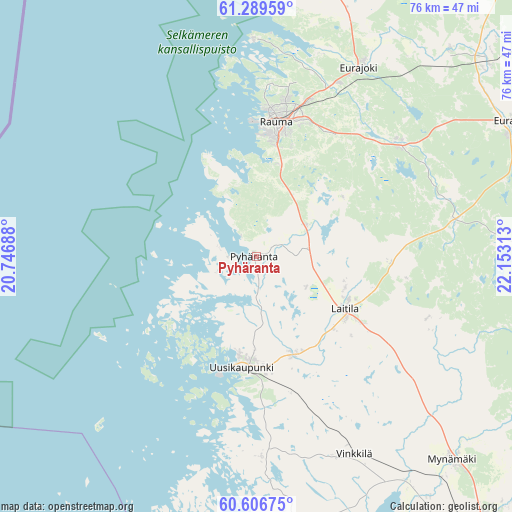
Pyhäranta GPS coordinates[2]
60° 57' 0" North, 21° 27' 0" East
| Map corner | latitude | longitude |
|---|---|---|
| Upper-left | 61.28959°, | 20.74688° |
| Center: | 60.95°, | 21.45° |
| Lower-right: | 60.60675°, | 22.15313° |
| Map W x H: | 75.9×75.9 km | = 47.2×47.2mi |
| max Lat: | 69.90864° ⇑70.5% North |
| Pyhäranta: | 60.95° |
| min Lat: | ⇓29.5% South 59.83333° |
| min Long | Pyhäranta | max Long |
| 21.2° | 21.45° | 30.93276° |
| W 1.9%⇐ | ⇒98.1% E |
Elevation
Elevation of Pyhäranta is 26 m = 85 ft, and this is 51.1 m = 168 ft below average elevation for this country.
| Max E: |
299 m = 981 ft | 76.5% |
| Avg. | 77.1 m = 253 ft | |
| Pyhäranta | 26 m = 85 ft | |
Min E: |
1 m = 3 ft | 23.5% |
See also: Finland elevation on elevation.city.
Geographical zone
Pyhäranta is located in North temperate zone (between Tropic of Cancer and the Arctic Circle). Distance of this North polar circle is 624.2 km =387.9 mi to North.| Distance of | km | miles | from Pyhäranta |
|---|---|---|---|
| North Pole | 3230.1 | 2007.1 | to North |
| Arctic Circle | 624.2 | 387.9 | to North |
| Tropic Cancer | 4171.1 | 2591.8 | to South |
| Equator | 6777 | 4211 | to South |


Nearby cities:
15 places around Pyhäranta: (largest is in red/bold)
• Eura
42.1 km =26.2 mi,  61°
61°
• Eurajoki
31.7 km =19.7 mi,  28°
28°
• Kiukainen
45.2 km =28.1 mi,  48°
48°
• Kodisjoki
16.1 km =10 mi, 56°
• Kustavi
45.3 km =28.1 mi,  186°
186°
• Laitila
15.7 km =9.8 mi,  121°
121°
• Lappi
26.5 km =16.5 mi, 51°
• Luvia
47 km =29.2 mi,  11°
11°
• Mietoinen
43.9 km =27.3 mi,  143°
143°
• Mynämäki
42.1 km =26.2 mi, 135°
• Rauma
20 km =12.4 mi, 9°
• Taivassalo
44.2 km =27.5 mi,  168°
168°
• Uusikaupunki
16.8 km =10.4 mi, 187°
• Vehmaa
31.9 km =19.8 mi,  158°
158°
• Vinkkilä
33 km =20.5 mi,  154°
154°
Sources, notices
• [Note1] Compared only with cities in Finland existing in our database
• [Src1] Map data: © OpenStreetMap contributors (CC-BY-SA)
• [Src2] Other city data from geonames.org with taken over terms of usage.
• [Src3] Geographical zone / Annual Mean Temperature by Robert A. Rohde @ Wikipedia
