Rauma geodata
Rauma (Satakunta) is a seat of a third-order administrative division; located in Finland in Europe/Helsinki (GMT+3) time zone. With population of 36,550 people, there are 20 cities with bigger population in this country. Compared to other cities in Finland, 65.6% of cities are located further ↑North; 97.6% of cities are located further →East and 87.6% of cities have higher elevation than Rauma. Note1


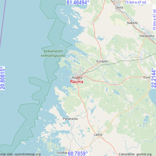
Rauma GPS coordinates[2]
61° 7' 38.064" North, 21° 30' 40.572" East
| Map corner | latitude | longitude |
|---|---|---|
| Upper-left | 61.46494°, | 20.80815° |
| Center: | 61.12724°, | 21.51127° |
| Lower-right: | 60.7859°, | 22.2144° |
| Map W x H: | 75.5×75.5 km | = 46.9×46.9mi |
| max Lat: | 69.90864° ⇑65.6% North |
| Rauma: | 61.12724° |
| min Lat: | ⇓34.4% South 59.83333° |
| min Long | Rauma | max Long |
| 21.2° | 21.51127° | 30.93276° |
| W 2.4%⇐ | ⇒97.6% E |
Elevation
Elevation of Rauma is 14 m = 46 ft, and this is 63.1 m = 207 ft below average elevation for this country.
| Max E: |
299 m = 981 ft | 87.6% |
| Avg. | 77.1 m = 253 ft | |
| Rauma | 14 m = 46 ft | |
Min E: |
1 m = 3 ft | 12.4% |
See also: Finland elevation on elevation.city.
Geographical zone
Rauma is located in North temperate zone (between Tropic of Cancer and the Arctic Circle). Distance of this North polar circle is 604.5 km =375.6 mi to North.| Distance of | km | miles | from Rauma |
|---|---|---|---|
| North Pole | 3210.3 | 1994.8 | to North |
| Arctic Circle | 604.5 | 375.6 | to North |
| Tropic Cancer | 4190.8 | 2604 | to South |
| Equator | 6796.7 | 4223.3 | to South |


Nearby cities:
15 places around Rauma: (largest is in red/bold)
• Eura
33.4 km =20.8 mi,  88°
88°
• Eurajoki
14.4 km =8.9 mi,  55°
55°
• Harjavalta
39.4 km =24.5 mi, 57°
• Kiukainen
32.2 km =20 mi,  72°
72°
• Kodisjoki
14.9 km =9.3 mi,  136°
136°
• Köyliö
42.9 km =26.7 mi, 91°
• Laitila
29.7 km =18.5 mi,  160°
160°
• Lappi
17.6 km =10.9 mi,  99°
99°
• Luvia
27 km =16.8 mi,  13°
13°
• Nakkila
37.3 km =23.2 mi,  44°
44°
• Pori
42.2 km =26.2 mi,  20°
20°
• Pyhäranta
20 km =12.4 mi,  189°
189°
• Säkylä
45.4 km =28.2 mi, 103°
• Ulvila
38.6 km =24 mi,  29°
29°
• Uusikaupunki
36.8 km =22.9 mi, 188°
Sources, notices
• [Note1] Compared only with cities in Finland existing in our database
• [Src1] Map data: © OpenStreetMap contributors (CC-BY-SA)
• [Src2] Other city data from geonames.org with taken over terms of usage.
• [Src3] Geographical zone / Annual Mean Temperature by Robert A. Rohde @ Wikipedia
