Kustavi geodata
Kustavi (Southwest Finland) is a seat of a third-order administrative division; located in Finland in Europe/Helsinki (GMT+3) time zone. With population of 951 people, there are 428 cities with bigger population in this country. Compared to other cities in Finland, 83.1% of cities are located further ↑North; 99.4% of cities are located further →East and 87.6% of cities have higher elevation than Kustavi. Note1


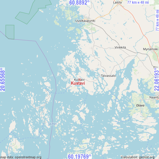
Kustavi GPS coordinates[2]
60° 32' 43.044" North, 21° 21' 31.68" East
| Map corner | latitude | longitude |
|---|---|---|
| Upper-left | 60.8892°, | 20.65568° |
| Center: | 60.54529°, | 21.3588° |
| Lower-right: | 60.19769°, | 22.06193° |
| Map W x H: | 76.9×76.9 km | = 47.8×47.8mi |
| max Lat: | 69.90864° ⇑83.1% North |
| Kustavi: | 60.54529° |
| min Lat: | ⇓16.9% South 59.83333° |
| min Long | Kustavi | max Long |
| 21.2° | 21.3588° | 30.93276° |
| W 0.6%⇐ | ⇒99.4% E |
Elevation
Elevation of Kustavi is 14 m = 46 ft, and this is 63.1 m = 207 ft below average elevation for this country.
| Max E: |
299 m = 981 ft | 87.6% |
| Avg. | 77.1 m = 253 ft | |
| Kustavi | 14 m = 46 ft | |
Min E: |
1 m = 3 ft | 12.4% |
See also: Finland elevation on elevation.city.
Geographical zone
Kustavi is located in North temperate zone (between Tropic of Cancer and the Arctic Circle). Distance of this North polar circle is 669.2 km =415.8 mi to North.| Distance of | km | miles | from Kustavi |
|---|---|---|---|
| North Pole | 3275.1 | 2035.1 | to North |
| Arctic Circle | 669.2 | 415.8 | to North |
| Tropic Cancer | 4126.1 | 2563.8 | to South |
| Equator | 6732 | 4183.1 | to South |


Nearby cities:
15 places around Kustavi: (largest is in red/bold)
• Askainen
27.9 km =17.3 mi,  85°
85°
• Houtskär
35.9 km =22.3 mi,  178°
178°
• Iniö
16.3 km =10.1 mi,  172°
172°
• Lemu
33.3 km =20.7 mi, 85°
• Merimasku
28.6 km =17.8 mi,  103°
103°
• Mietoinen
32.9 km =20.4 mi,  72°
72°
• Mynämäki
37.7 km =23.4 mi, 66°
• Naantali
37.4 km =23.2 mi, 103°
• Nousiainen
39.9 km =24.8 mi,  80°
80°
• Rymättylä
37.1 km =23.1 mi,  120°
120°
• Taivassalo
14.2 km =8.8 mi, 82°
• Uusikaupunki
28.5 km =17.7 mi,  5°
5°
• Vehmaa
22.8 km =14.2 mi,  47°
47°
• Velkua
19 km =11.8 mi, 117°
• Vinkkilä
24.8 km =15.4 mi, 51°
Sources, notices
• [Note1] Compared only with cities in Finland existing in our database
• [Src1] Map data: © OpenStreetMap contributors (CC-BY-SA)
• [Src2] Other city data from geonames.org with taken over terms of usage.
• [Src3] Geographical zone / Annual Mean Temperature by Robert A. Rohde @ Wikipedia
