Hyvinge geodata
Hyvinge (Uusimaa) is a seat of a third-order administrative division; located in Finland in Europe/Helsinki (GMT+3) time zone. With population of 43,515 people, there are 17 cities with bigger population in this country. Compared to other cities in Finland, 79.9% of cities are located further ↑North; 52.4% of cities are located further ←West and 76.3% of cities have lower elevation than Hyvinge. Note1


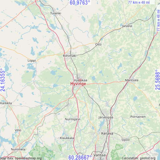
Hyvinge GPS coordinates[2]
60° 37' 59.988" North, 24° 52' 0.012" East
| Map corner | latitude | longitude |
|---|---|---|
| Upper-left | 60.9763°, | 24.16355° |
| Center: | 60.63333°, | 24.86667° |
| Lower-right: | 60.28667°, | 25.5698° |
| Map W x H: | 76.7×76.7 km | = 47.7×47.7mi |
| max Lat: | 69.90864° ⇑79.9% North |
| Hyvinge: | 60.63333° |
| min Lat: | ⇓20.1% South 59.83333° |
| min Long | Hyvinge | max Long |
| 21.2° | 24.86667° | 30.93276° |
| W 52.4%⇐ | ⇒47.6% E |
Elevation
Elevation of Hyvinge is 113 m = 371 ft, and this is 35.9 m = 118 ft above average elevation for this country.
| Max E: |
299 m = 981 ft | 23.7% |
| Hyvinge | 113 m 371 ft | |
| Avg. | 77.1 m = 253 ft | |
Min E: |
1 m = 3 ft | 76.3% |
See also: Hyvinge elevation on elevation.city.
Geographical zone
Hyvinge is located in North temperate zone (between Tropic of Cancer and the Arctic Circle). Distance of this North polar circle is 659.4 km =409.7 mi to North.| Distance of | km | miles | from Hyvinge |
|---|---|---|---|
| North Pole | 3265.3 | 2029 | to North |
| Arctic Circle | 659.4 | 409.7 | to North |
| Tropic Cancer | 4135.9 | 2569.9 | to South |
| Equator | 6741.8 | 4189.2 | to South |


Nearby cities:
15 places around Hyvinge: (largest is in red/bold)
• Hausjärvi
17.1 km =10.6 mi,  12°
12°
• Janakkala
33 km =20.5 mi,  333°
333°
• Järvelä
34.4 km =21.4 mi,  41°
41°
• Järvenpää
21.5 km =13.4 mi,  145°
145°
• Kellokoski
17.3 km =10.7 mi,  130°
130°
• Kerava
28.7 km =17.8 mi, 152°
• Loppi
24.5 km =15.2 mi,  292°
292°
• Mäntsälä
24.5 km =15.2 mi,  90°
90°
• Nurmijärvi
19.1 km =11.9 mi,  189°
189°
• Oitti
19 km =11.8 mi,  28°
28°
• Pornainen
32.8 km =20.4 mi,  122°
122°
• Riihimäki
12.6 km =7.8 mi,  337°
337°
• Tervakoski
24 km =14.9 mi, 326°
• Turenki
34 km =21.1 mi, 338°
• Tuusula
27 km =16.8 mi,  161°
161°
In other languages:
- In Spanish: Hyvinkää
- In France: Hyvinkää
- In German: Hyvinkää
- In Italian: Hyvinkää
- In Russian: Хювинкяя
Sources, notices
• [Note1] Compared only with cities in Finland existing in our database
• [Src1] Map data: © OpenStreetMap contributors (CC-BY-SA)
• [Src2] Other city data from geonames.org with taken over terms of usage.
• [Src3] Geographical zone / Annual Mean Temperature by Robert A. Rohde @ Wikipedia
