Kellokoski geodata
Kellokoski (Uusimaa) is a populated place; located in Finland in Europe/Helsinki (GMT+3) time zone. With population of 4,300 people, there are 238 cities with bigger population in this country. Compared to other cities in Finland, 84% of cities are located further ↑North; 57.7% of cities are located further ←West and 60% of cities have higher elevation than Kellokoski. Note1


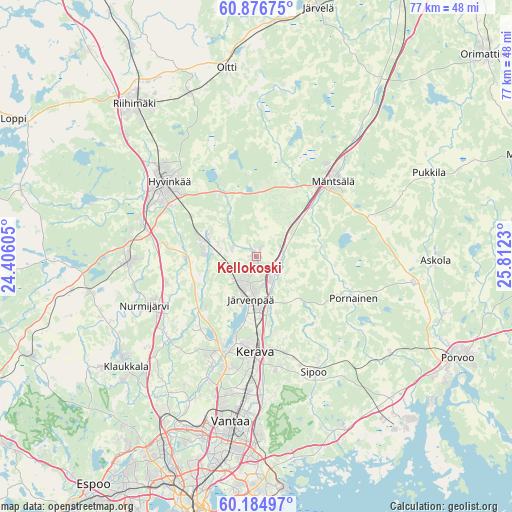
Kellokoski GPS coordinates[2]
60° 31' 57.756" North, 25° 6' 33.012" East
| Map corner | latitude | longitude |
|---|---|---|
| Upper-left | 60.87675°, | 24.40605° |
| Center: | 60.53271°, | 25.10917° |
| Lower-right: | 60.18497°, | 25.8123° |
| Map W x H: | 76.9×76.9 km | = 47.8×47.8mi |
| max Lat: | 69.90864° ⇑84% North |
| Kellokoski: | 60.53271° |
| min Lat: | ⇓16% South 59.83333° |
| min Long | Kellokoski | max Long |
| 21.2° | 25.10917° | 30.93276° |
| W 57.7%⇐ | ⇒42.3% E |
Elevation
Elevation of Kellokoski is 62 m = 203 ft, and this is 15.1 m = 50 ft below average elevation for this country.
| Max E: |
299 m = 981 ft | 60% |
| Avg. | 77.1 m = 253 ft | |
| Kellokoski | 62 m = 203 ft | |
Min E: |
1 m = 3 ft | 40% |
See also: Finland elevation on elevation.city.
Geographical zone
Kellokoski is located in North temperate zone (between Tropic of Cancer and the Arctic Circle). Distance of this North polar circle is 670.6 km =416.7 mi to North.| Distance of | km | miles | from Kellokoski |
|---|---|---|---|
| North Pole | 3276.5 | 2035.9 | to North |
| Arctic Circle | 670.6 | 416.7 | to North |
| Tropic Cancer | 4124.7 | 2563 | to South |
| Equator | 6730.6 | 4182.2 | to South |


Nearby cities:
15 places around Kellokoski: (largest is in red/bold)
• Askola
26.8 km =16.7 mi,  89°
89°
• Hausjärvi
29.5 km =18.3 mi,  341°
341°
• Hyvinge
17.3 km =10.7 mi,  310°
310°
• Järvenpää
6.6 km =4.1 mi,  189°
189°
• Kerava
14.4 km =8.9 mi,  180°
180°
• Mäntsälä
15.9 km =9.9 mi,  45°
45°
• Nickby
19.2 km =11.9 mi,  150°
150°
• Nurmijärvi
18.2 km =11.3 mi,  245°
245°
• Oitti
28.2 km =17.5 mi,  351°
351°
• Pornainen
15.9 km =9.9 mi,  113°
113°
• Pukkila
28.2 km =17.5 mi,  62°
62°
• Riihimäki
29.1 km =18.1 mi,  321°
321°
• Sibbo
19.4 km =12.1 mi, 153°
• Tuusula
15 km =9.3 mi,  197°
197°
• Vantaa
26.8 km =16.7 mi, 188°
Sources, notices
• [Note1] Compared only with cities in Finland existing in our database
• [Src1] Map data: © OpenStreetMap contributors (CC-BY-SA)
• [Src2] Other city data from geonames.org with taken over terms of usage.
• [Src3] Geographical zone / Annual Mean Temperature by Robert A. Rohde @ Wikipedia
