Hyrynsalmi geodata
Hyrynsalmi (Kainuu) is a seat of a third-order administrative division; located in Finland in Europe/Helsinki (GMT+3) time zone. With population of 3,087 people, there are 292 cities with bigger population in this country. Compared to other cities in Finland, 89.7% of cities are located further ↓South; 92.3% of cities are located further ←West and 92.3% of cities have lower elevation than Hyrynsalmi. Note1


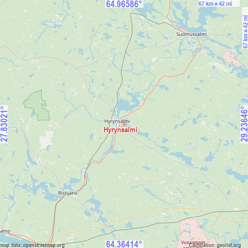
Hyrynsalmi GPS coordinates[2]
64° 40' 0.012" North, 28° 31' 59.988" East
| Map corner | latitude | longitude |
|---|---|---|
| Upper-left | 64.96586°, | 27.83021° |
| Center: | 64.66667°, | 28.53333° |
| Lower-right: | 64.36414°, | 29.23646° |
| Map W x H: | 66.9×66.9 km | = 41.6×41.6mi |
| max Lat: | 69.90864° ⇑10.3% North |
| Hyrynsalmi: | 64.66667° |
| min Lat: | ⇓89.7% South 59.83333° |
| min Long | Hyrynsalmi | max Long |
| 21.2° | 28.53333° | 30.93276° |
| W 92.3%⇐ | ⇒7.7% E |
Elevation
Elevation of Hyrynsalmi is 148 m = 486 ft, and this is 70.9 m = 233 ft above average elevation for this country.
| Max E: |
299 m = 981 ft | 7.7% |
| Hyrynsalmi | 148 m 486 ft | |
| Avg. | 77.1 m = 253 ft | |
Min E: |
1 m = 3 ft | 92.3% |
See also: Finland elevation on elevation.city.
Geographical zone
Hyrynsalmi is located in North temperate zone (between Tropic of Cancer and the Arctic Circle). Distance of this North polar circle is 210.9 km =131 mi to North.| Distance of | km | miles | from Hyrynsalmi |
|---|---|---|---|
| North Pole | 2816.8 | 1750.3 | to North |
| Arctic Circle | 210.9 | 131 | to North |
| Tropic Cancer | 4584.3 | 2848.6 | to South |
| Equator | 7190.3 | 4467.8 | to South |


Nearby cities:
15 places around Hyrynsalmi: (largest is in red/bold)
• Kajaani
62.3 km =38.7 mi,  218°
218°
• Kestilä
113.5 km =70.5 mi,  251°
251°
• Kuhmo
75.8 km =47.1 mi,  141°
141°
• Paltamo
43.5 km =27 mi,  230°
230°
• Pudasjärvi
110 km =68.4 mi,  316°
316°
• Puolanka
46.7 km =29 mi,  298°
298°
• Ristijärvi
23.9 km =14.9 mi, 219°
• Sotkamo
59.6 km =37 mi,  185°
185°
• Suomussalmi
30.2 km =18.8 mi,  35°
35°
• Taivalkoski
100.9 km =62.7 mi,  352°
352°
• Utajärvi
102.5 km =63.7 mi,  275°
275°
• Vaala
81.8 km =50.8 mi,  262°
262°
• Valtimo
111.9 km =69.5 mi,  173°
173°
• Vuokatti
59.3 km =36.8 mi, 191°
• Vuolijoki
91.2 km =56.7 mi, 234°
Sources, notices
• [Note1] Compared only with cities in Finland existing in our database
• [Src1] Map data: © OpenStreetMap contributors (CC-BY-SA)
• [Src2] Other city data from geonames.org with taken over terms of usage.
• [Src3] Geographical zone / Annual Mean Temperature by Robert A. Rohde @ Wikipedia
