Vaala geodata
Vaala (Kainuu) is a seat of a third-order administrative division; located in Finland in Europe/Helsinki (GMT+3) time zone. With population of 3,652 people, there are 258 cities with bigger population in this country. Compared to other cities in Finland, 89.5% of cities are located further ↓South; 78% of cities are located further ←West and 88.7% of cities have lower elevation than Vaala. Note1


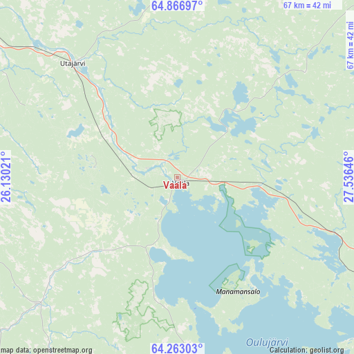
Vaala GPS coordinates[2]
64° 34' 0.012" North, 26° 49' 59.988" East
| Map corner | latitude | longitude |
|---|---|---|
| Upper-left | 64.86697°, | 26.13021° |
| Center: | 64.56667°, | 26.83333° |
| Lower-right: | 64.26303°, | 27.53646° |
| Map W x H: | 67.2×67.1 km | = 41.8×41.7mi |
| max Lat: | 69.90864° ⇑10.5% North |
| Vaala: | 64.56667° |
| min Lat: | ⇓89.5% South 59.83333° |
| min Long | Vaala | max Long |
| 21.2° | 26.83333° | 30.93276° |
| W 78%⇐ | ⇒22% E |
Elevation
Elevation of Vaala is 138 m = 453 ft, and this is 60.9 m = 200 ft above average elevation for this country.
| Max E: |
299 m = 981 ft | 11.3% |
| Vaala | 138 m 453 ft | |
| Avg. | 77.1 m = 253 ft | |
Min E: |
1 m = 3 ft | 88.7% |
See also: Finland elevation on elevation.city.
Geographical zone
Vaala is located in North temperate zone (between Tropic of Cancer and the Arctic Circle). Distance of this North polar circle is 222 km =137.9 mi to North.| Distance of | km | miles | from Vaala |
|---|---|---|---|
| North Pole | 2827.9 | 1757.2 | to North |
| Arctic Circle | 222 | 137.9 | to North |
| Tropic Cancer | 4573.2 | 2841.7 | to South |
| Equator | 7179.1 | 4460.9 | to South |


Nearby cities:
15 places around Vaala: (largest is in red/bold)
• Kajaani
57.2 km =35.5 mi,  131°
131°
• Kestilä
35.9 km =22.3 mi,  227°
227°
• Muhos
41.4 km =25.7 mi,  302°
302°
• Muhos
48.1 km =29.9 mi, 303°
• Paltamo
50.7 km =31.5 mi,  109°
109°
• Piippola
61 km =37.9 mi,  223°
223°
• Pulkkila
57.2 km =35.5 mi, 234°
• Puolanka
51.8 km =32.2 mi,  49°
49°
• Pyhäntä
57.5 km =35.7 mi,  205°
205°
• Rantsila
56.3 km =35 mi,  263°
263°
• Ristijärvi
66.6 km =41.4 mi,  96°
96°
• Tyrnävä
60.3 km =37.5 mi,  291°
291°
• Utajärvi
29.6 km =18.4 mi,  313°
313°
• Vuolijoki
43.1 km =26.8 mi,  169°
169°
• Ylikiiminki
63.7 km =39.6 mi,  334°
334°
Sources, notices
• [Note1] Compared only with cities in Finland existing in our database
• [Src1] Map data: © OpenStreetMap contributors (CC-BY-SA)
• [Src2] Other city data from geonames.org with taken over terms of usage.
• [Src3] Geographical zone / Annual Mean Temperature by Robert A. Rohde @ Wikipedia
