Watten geodata
Watten (Hauts-de-France) is a populated place; located in France in Europe/Paris (GMT+2) time zone. With population of 3,000 people, there are 3252 cities with bigger population in this country. Compared to other cities in France, 99.5% of cities are located further ↓South; 54.2% of cities are located further →East and 99.3% of cities have higher elevation than Watten. Note1
Administrative division(s):
- Level 1: Hauts-de-France
- Level 2: Nord
- Level 3: Arrondissement de Dunkerque
- Level 4: Watten


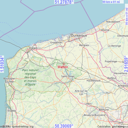
Watten GPS coordinates[2]
50° 50' 12.66" North, 2° 12' 48.456" East
| Map corner | latitude | longitude |
|---|---|---|
| Upper-left | 51.27878°, | 1.51034° |
| Center: | 50.83685°, | 2.21346° |
| Lower-right: | 50.39069°, | 2.91659° |
| Map W x H: | 98.7×98.7 km | = 61.3×61.3mi |
| max Lat: | 51.07786° ⇑0.5% North |
| Watten: | 50.83685° |
| min Lat: | ⇓99.5% South 41.3874° |
| min Long | Watten | max Long |
| -5.08615° | 2.21346° | 9.52242° |
| W 45.8%⇐ | ⇒54.2% E |
Elevation
Elevation of Watten is 5 m = 16 ft, and this is 188.7 m = 619 ft below average elevation for this country.
| Max E: |
2333 m = 7654 ft | 99.3% |
| Avg. | 193.7 m = 635 ft | |
| Watten | 5 m = 16 ft | |
Min E: |
-1 m = -3 ft | 0.7% |
See also: France elevation on elevation.city.
Geographical zone
Watten is located in North temperate zone (between Tropic of Cancer and the Arctic Circle). Distance of this North polar circle is 1748.6 km =1086.5 mi to North.| Distance of | km | miles | from Watten |
|---|---|---|---|
| North Pole | 4354.5 | 2705.8 | to North |
| Arctic Circle | 1748.6 | 1086.5 | to North |
| Tropic Cancer | 3046.6 | 1893.1 | to South |
| Equator | 5652.5 | 3512.3 | to South |


Nearby cities:
15 places around Watten: (largest is in red/bold)
• Bayenghem-lès-Éperlecques
7.2 km =4.5 mi,  243°
243°
• Holque
2.1 km =1.3 mi,  340°
340°
• Houlle
5.4 km =3.4 mi,  211°
211°
• Lederzeele
6.5 km =4 mi,  106°
106°
• Merckeghem
6.5 km =4 mi,  64°
64°
• Millam
3.2 km =2 mi,  51°
51°
• Moulle
5.9 km =3.7 mi, 205°
• Nieurlet
7.2 km =4.5 mi,  137°
137°
• Ruminghem
4.6 km =2.9 mi,  302°
302°
• Saint-Pierre-Brouck
6.8 km =4.2 mi, 343°
• Salperwick
7.1 km =4.4 mi,  169°
169°
• Serques
4.9 km =3 mi,  189°
189°
• Tilques
6.7 km =4.2 mi, 188°
• Volckerinckhove
6.5 km =4 mi,  87°
87°
• Éperlecques
5.5 km =3.4 mi,  231°
231°
Sources, notices
• [Note1] Compared only with cities in France existing in our database
• [Src1] Map data: © OpenStreetMap contributors (CC-BY-SA)
• [Src2] Other city data from geonames.org with taken over terms of usage.
• [Src3] Geographical zone / Annual Mean Temperature by Robert A. Rohde @ Wikipedia
