Ruminghem geodata
Ruminghem (Hauts-de-France) is a populated place; located in France in Europe/Paris (GMT+2) time zone. With population of 1,200 people, there are 7535 cities with bigger population in this country. Compared to other cities in France, 99.5% of cities are located further ↓South; 55% of cities are located further →East and 99.6% of cities have higher elevation than Ruminghem. Note1
Administrative division(s):
- Level 1: Hauts-de-France
- Level 2: Pas-de-Calais
- Level 3: Arrondissement de Calais
- Level 4: Ruminghem


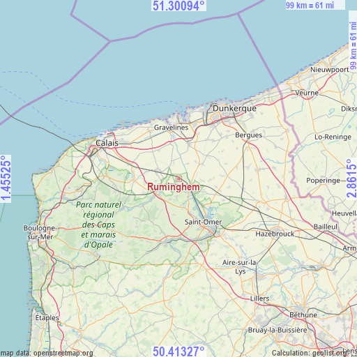
Ruminghem GPS coordinates[2]
50° 51' 33.192" North, 2° 9' 30.168" East
| Map corner | latitude | longitude |
|---|---|---|
| Upper-left | 51.30094°, | 1.45525° |
| Center: | 50.85922°, | 2.15838° |
| Lower-right: | 50.41327°, | 2.8615° |
| Map W x H: | 98.7×98.7 km | = 61.3×61.3mi |
| max Lat: | 51.07786° ⇑0.5% North |
| Ruminghem: | 50.85922° |
| min Lat: | ⇓99.5% South 41.3874° |
| min Long | Ruminghem | max Long |
| -5.08615° | 2.15838° | 9.52242° |
| W 45%⇐ | ⇒55% E |
Elevation
Elevation of Ruminghem is 4 m = 13 ft, and this is 189.7 m = 622 ft below average elevation for this country.
| Max E: |
2333 m = 7654 ft | 99.6% |
| Avg. | 193.7 m = 635 ft | |
| Ruminghem | 4 m = 13 ft | |
Min E: |
-1 m = -3 ft | 0.4% |
See also: France elevation on elevation.city.
Geographical zone
Ruminghem is located in North temperate zone (between Tropic of Cancer and the Arctic Circle). Distance of this North polar circle is 1746.2 km =1085 mi to North.| Distance of | km | miles | from Ruminghem |
|---|---|---|---|
| North Pole | 4352 | 2704.2 | to North |
| Arctic Circle | 1746.2 | 1085 | to North |
| Tropic Cancer | 3049.1 | 1894.6 | to South |
| Equator | 5655 | 3513.9 | to South |


Nearby cities:
15 places around Ruminghem: (largest is in red/bold)
• Audruicq
5.9 km =3.7 mi,  290°
290°
• Bayenghem-lès-Éperlecques
6.3 km =3.9 mi,  204°
204°
• Holque
3.2 km =2 mi,  99°
99°
• Houlle
7.2 km =4.5 mi,  171°
171°
• Millam
6.4 km =4 mi,  94°
94°
• Moulle
7.9 km =4.9 mi, 170°
• Nordausques
7.1 km =4.4 mi,  230°
230°
• Polincove
4.9 km =3 mi,  254°
254°
• Recques-sur-Hem
5.7 km =3.5 mi,  240°
240°
• Saint-Pierre-Brouck
4.5 km =2.8 mi,  25°
25°
• Sainte-Marie-Kerque
4.7 km =2.9 mi,  341°
341°
• Serques
7.9 km =4.9 mi,  157°
157°
• Watten
4.6 km =2.9 mi,  122°
122°
• Zutkerque
6.4 km =4 mi,  263°
263°
• Éperlecques
6 km =3.7 mi,  184°
184°
Sources, notices
• [Note1] Compared only with cities in France existing in our database
• [Src1] Map data: © OpenStreetMap contributors (CC-BY-SA)
• [Src2] Other city data from geonames.org with taken over terms of usage.
• [Src3] Geographical zone / Annual Mean Temperature by Robert A. Rohde @ Wikipedia
