Villerville geodata
Villerville (Normandy) is a populated place; located in France in Europe/Paris (GMT+2) time zone. With population of 714 people, there are 11603 cities with bigger population in this country. Compared to other cities in France, 87.9% of cities are located further ↓South; 76.9% of cities are located further →East and 90.7% of cities have higher elevation than Villerville. Note1
Administrative division(s):
- Level 1: Normandy
- Level 2: Calvados
- Level 3: Arrondissement de Lisieux
- Level 4: Villerville


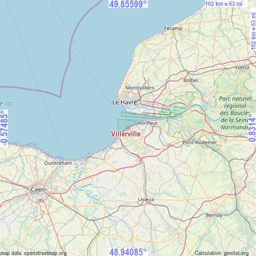
Villerville GPS coordinates[2]
49° 24' 1.98" North, 0° 7' 41.808" East
| Map corner | latitude | longitude |
|---|---|---|
| Upper-left | 49.85599°, | -0.57485° |
| Center: | 49.40055°, | 0.12828° |
| Lower-right: | 48.94085°, | 0.8314° |
| Map W x H: | 101.8×101.8 km | = 63.3×63.3mi |
| max Lat: | 51.07786° ⇑12.1% North |
| Villerville: | 49.40055° |
| min Lat: | ⇓87.9% South 41.3874° |
| min Long | Villerville | max Long |
| -5.08615° | 0.12828° | 9.52242° |
| W 23.1%⇐ | ⇒76.9% E |
Elevation
Elevation of Villerville is 28 m = 92 ft, and this is 165.7 m = 544 ft below average elevation for this country.
| Max E: |
2333 m = 7654 ft | 90.7% |
| Avg. | 193.7 m = 635 ft | |
| Villerville | 28 m = 92 ft | |
Min E: |
-1 m = -3 ft | 9.3% |
See also: France elevation on elevation.city.
Geographical zone
Villerville is located in North temperate zone (between Tropic of Cancer and the Arctic Circle). Distance of this North polar circle is 1908.3 km =1185.8 mi to North.| Distance of | km | miles | from Villerville |
|---|---|---|---|
| North Pole | 4514.2 | 2805 | to North |
| Arctic Circle | 1908.3 | 1185.8 | to North |
| Tropic Cancer | 2886.9 | 1793.8 | to South |
| Equator | 5492.8 | 3413.1 | to South |


Nearby cities:
15 places around Villerville: (largest is in red/bold)
• Ablon
12.2 km =7.6 mi,  94°
94°
• Benerville-sur-Mer
8.9 km =5.5 mi,  230°
230°
• Blonville-sur-Mer
10.2 km =6.3 mi, 226°
• Deauville
6.4 km =4 mi,  221°
221°
• Genneville
11.2 km =7 mi,  107°
107°
• Gonneville-sur-Honfleur
8.6 km =5.3 mi,  101°
101°
• Honfleur
7.9 km =4.9 mi,  74°
74°
• La Rivière-Saint-Sauveur
10.3 km =6.4 mi, 85°
• Le Havre
10.5 km =6.5 mi,  351°
351°
• Saint-Arnoult
7.5 km =4.7 mi,  201°
201°
• Saint-Gatien-des-Bois
6.9 km =4.3 mi,  144°
144°
• Touques
6.5 km =4 mi, 196°
• Tourgeville
9.8 km =6.1 mi,  205°
205°
• Trouville-sur-Mer
5.2 km =3.2 mi, 221°
• Équemauville
5.8 km =3.6 mi, 97°
Sources, notices
• [Note1] Compared only with cities in France existing in our database
• [Src1] Map data: © OpenStreetMap contributors (CC-BY-SA)
• [Src2] Other city data from geonames.org with taken over terms of usage.
• [Src3] Geographical zone / Annual Mean Temperature by Robert A. Rohde @ Wikipedia
