Honfleur geodata
Honfleur (Normandy) is a populated place; located in France in Europe/Paris (GMT+2) time zone. With population of 8,148 people, there are 1187 cities with bigger population in this country. Compared to other cities in France, 88.3% of cities are located further ↓South; 76% of cities are located further →East and 99% of cities have higher elevation than Honfleur. Note1
Administrative division(s):
- Level 1: Normandy
- Level 2: Calvados
- Level 3: Arrondissement de Lisieux
- Level 4: Honfleur


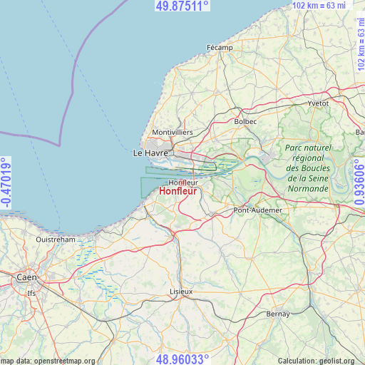
Honfleur GPS coordinates[2]
49° 25' 11.46" North, 0° 13' 58.584" East
| Map corner | latitude | longitude |
|---|---|---|
| Upper-left | 49.87511°, | -0.47019° |
| Center: | 49.41985°, | 0.23294° |
| Lower-right: | 48.96033°, | 0.93606° |
| Map W x H: | 101.7×101.7 km | = 63.2×63.2mi |
| max Lat: | 51.07786° ⇑11.7% North |
| Honfleur: | 49.41985° |
| min Lat: | ⇓88.3% South 41.3874° |
| min Long | Honfleur | max Long |
| -5.08615° | 0.23294° | 9.52242° |
| W 24%⇐ | ⇒76% E |
Elevation
Elevation of Honfleur is 6 m = 20 ft, and this is 187.7 m = 616 ft below average elevation for this country.
| Max E: |
2333 m = 7654 ft | 99% |
| Avg. | 193.7 m = 635 ft | |
| Honfleur | 6 m = 20 ft | |
Min E: |
-1 m = -3 ft | 1% |
See also: France elevation on elevation.city.
Geographical zone
Honfleur is located in North temperate zone (between Tropic of Cancer and the Arctic Circle). Distance of this North polar circle is 1906.2 km =1184.5 mi to North.| Distance of | km | miles | from Honfleur |
|---|---|---|---|
| North Pole | 4512.1 | 2803.7 | to North |
| Arctic Circle | 1906.2 | 1184.5 | to North |
| Tropic Cancer | 2889.1 | 1795.2 | to South |
| Equator | 5495 | 3414.4 | to South |


Nearby cities:
15 places around Honfleur: (largest is in red/bold)
• Ablon
5.5 km =3.4 mi,  124°
124°
• Beuzeville
11.5 km =7.1 mi,  136°
136°
• Fatouville-Grestain
7 km =4.3 mi,  103°
103°
• Fiquefleur-Équainville
6.8 km =4.2 mi,  111°
111°
• Gainneville
11.2 km =7 mi,  10°
10°
• Genneville
6.4 km =4 mi,  151°
151°
• Gonneville-sur-Honfleur
4 km =2.5 mi,  167°
167°
• Harfleur
10 km =6.2 mi,  345°
345°
• La Rivière-Saint-Sauveur
3 km =1.9 mi, 115°
• Rogerville
9.5 km =5.9 mi, 14°
• Saint-Gatien-des-Bois
8.6 km =5.3 mi,  204°
204°
• Saint-Pierre-du-Val
10 km =6.2 mi, 105°
• Sandouville
10.6 km =6.6 mi,  35°
35°
• Villerville
7.9 km =4.9 mi,  254°
254°
• Équemauville
3.4 km =2.1 mi,  212°
212°
Sources, notices
• [Note1] Compared only with cities in France existing in our database
• [Src1] Map data: © OpenStreetMap contributors (CC-BY-SA)
• [Src2] Other city data from geonames.org with taken over terms of usage.
• [Src3] Geographical zone / Annual Mean Temperature by Robert A. Rohde @ Wikipedia
